
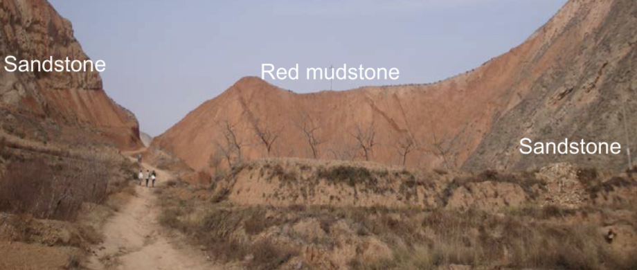
Featured image: From Fig. 1 in Ao et al. (2021). An image of the Late Oligocene-age red mudstone that is the subject of this study, between bracketing sandstone sections. This mudstone outcrop (known as the Duittingou section) is located in the Lanzhou Basin, China, in the northeastern Tibetan Plateau. Image licensed under CC BY-NC.
Authors: Hong Ao, Diederik Liebrand, Mark J. Dekkers, Peng Zhang, Yougui Song, Qingsong Liu, Tara Jonell, Qiang Sun, Xinzhou Li, Xinxia Li, Xiaoke Qiang, Zhisheng An
The intensity and frequency of rainfall affects food supply around the world, the structural integrity of buildings and homes, and flooding in the impermeable “concrete jungles” of cities. However, not much is known about how rainfall has fluctuated naturally in the distant past, making it more difficult for scientists to predict how climate change will affect future precipitation. Recently, an international team of authors addressed a small part of this problem by uncovering how rainfall in Asia changed under different climates far back in time. Their scientific adventure started once they identified a particularly special rock formation in China, where invisible traces of ancient rainfall had been preserved.
On the northeastern edge of the Tibetan Plateau, the authors studied material from a ridge made of “mudstone,” a type of rock composed of compacted sand and soil grains. The grains forming the rocks of this particular ridge were deposited by mountain streams in an ancient floodplain. Beginning in the late Oligocene epoch (28.1 million years ago) and continuing for 4 million years, rainwaters had eroded and transported these grains from nearby mountains, leaving sediment piled up in layers. Later on, tectonic movement and weathering processes solidified, uplifted, and oxidized this multi-million year floodplain record, resulting in the reddish stone seen today.
Within samples of this red mudstone, Ao and his co-authors made two unique measurements: (1) the rubidium to strontium elemental ratio (Rb/Sr) and (2) low-field magnetic susceptibility – a way to quantify the amount of magnetic minerals present. Both measurements encoded information about the amount of local rainfall that occurred when the former sand grains had first been deposited. As weathering and rainfall increased, the floodplain sediments released more Sr and retained more Rb, resulting in a higher Rb/Sr ratio. Higher rainfall also meant that the steep mountain streams eroded and flushed more magnetic minerals from nearby slopes into the ancient floodplain, resulting in a higher magnetic susceptibility. Thus, periods of higher Rb/Sr and higher magnetic susceptibility in the mudrock both pointed to intervals of higher rainfall in the region (see Figure 1). Rainfall in the northeastern Tibetan Plateau stems dominantly from the Asian monsoon, and so these rainfall records indirectly reflect monsoon strength over the 4 million years when the sediments were deposited.
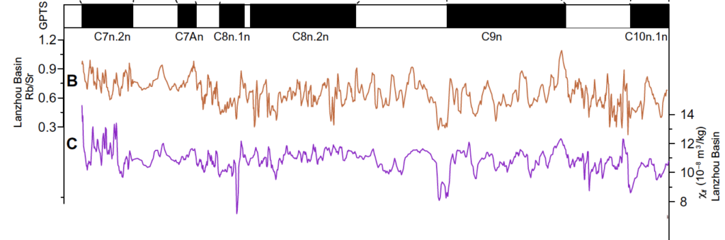
The authors found a strikingly cyclical pattern in their Rb/Sr and magnetic susceptibility records of monsoon rainfall. Over the entire 4 million year period recorded in the mudstone section, rainfall intensity oscillated regularly and quite predictably every 110,000 and 405,000 years. These periods of time are well-known to paleoclimate scientists and represent the time it takes for the eccentricity of Earth’s orbit around the Sun to fluctuate. Interestingly, reconstructions of Antarctic ice sheet size and global climate change during this same late Oligocene interval show this eccentricity pacing as well. The authors suggest that all of these processes may be connected through atmospheric and/or ocean circulation and could stem from long-term changes in sunlight hitting tropical regions, which eccentricity partly governs over hundreds of thousands of years. These postulated connections between frigid Antarctic glaciers and monsoon rainfall high in the Tibetan mountains are still uncertain, but this research shows that we still have much to learn about how hydrology varied during times when the world was much warmer than today and only one polar ice sheet existed.
It’s magnetic! Probing the predictability of ancient rainfall using a mountainous ridge of red stone by Lloyd Anderson is licensed under a Creative Commons Attribution-ShareAlike 4.0 International License.