How does dust from African and Asian deserts affect rainfall over California?

Featured image: Sand Dunes by Free-Photos on Pixabay

Paper: Dusty Atmospheric Rivers: Characteristics and Origins

Authors: Kara K. Voss, Amato T. Evan, Kimbery A. Prather, and F. Martin Ralph

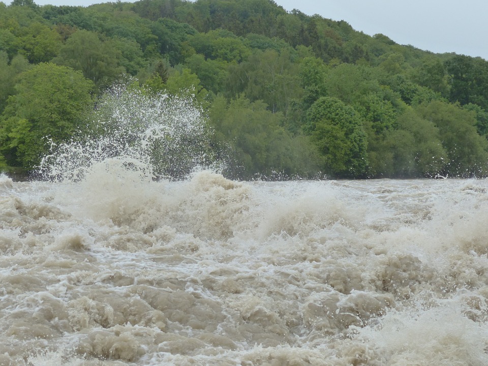
Atmospheric rivers, narrow plumes of highly concentrated water vapor in the atmosphere, can cause heavy rain over the coastal western United States and southwest Canada. In fact, up to half of California’s annual rainfall comes from atmospheric rivers, and while this rain helps replenish California’s water sources, it can also cause flooding and mudslides. A new study sheds light on how dust kicked up from deserts halfway around the world in Africa and Asia may influence these atmospheric rivers and control California’s rain patterns.

Continue reading “How does dust from African and Asian deserts affect rainfall over California?”

Small Sediment’s Big Impact on Flash Floods

Featured image by Hans from Pixabay.

Paper: Modeling the Effects of Sediment Concentration on the Propagation of Flash Floods in an Andean Watershed

Authors: María Teresa Contreras and Cristían Escauriaza

Climate change has altered weather patterns around the world and has even led to increased heavy rainfall in some regions.  This, combined with El Niño – a weather pattern produced by unusual winds that can cause some regions to experience heavier than normal rainfall – has led to high numbers of catastrophic flash floods in populated areas near the Andes mountains.  To add insult to injury, climate models predict increases in heavy rainfall events in the future, further worsening the chance for flash floods. New research from scientists working in Chile and the United States aims to model the impact of these floods on communities by simulating realistic flash flood conditions with different amounts of sediment, a potentially dangerous component of flash floods in mountainous regions.

Continue reading “Small Sediment’s Big Impact on Flash Floods”

Unexpected consequence of permafrost thaw: potentially less methane released into the atmosphere

Authors: Clarice R. Perryman, Carmody K. McCalley, Avni Malhotra, M. Florencia Fahnestock, Natalie N. Kashi, Julia G. Bryce, Reiner Giesler, Ruth K. Varner

Permafrost is a blanket of soil that is frozen for more than two years and can trap its contents for hundreds to thousands of years. Now that permafrost soil is thawing. This is particularly significant in peatland permafrost because these wetlands sequester high amounts of carbon. As peatland permafrost degrades, methane emissions are expected to increase as the water table rises and provides a suitable environment for methane production by microbes.

Continue reading “Unexpected consequence of permafrost thaw: potentially less methane released into the atmosphere”

Whose Faces do we See in Geology Textbooks?

Student standing on textbooks in library

Author’s Note: The last few weeks have left us grappling with the profound effects of systemic racism, as seen in the wake of the recent protests and violence all over the USA and the world, as well as the disproportionate effect of COVID-19 on Black communities. This week’s post is dedicated to exploring the impact of another effect of systemic racism: lack of representation in educational spaces, made apparent in geology textbooks. 

Continue reading “Whose Faces do we See in Geology Textbooks?”

Rivers of Memory: India

Paper: Evolution of modern river systems: an assessment of ‘landscape memory’ in Indian river systems

Authors: Vikrant Jain, Sonam, Ajit Singh, Rajiv Sinha, S. K. Tandon

“A river cuts through rock not because of its power, but because of its persistence.”

James N Watkins

In geomorphology, the persistence of rivers is etched into the very landscape – a memory of the forces that once shaped it, and continue to do so, slowly, and inexorably. Landscape memory, as Gary John Brierley once wrote, is the imprint of the past upon contemporary landscapes, which include geologic, climatic, and anthropogenic factors.

The rivers of the Indian subcontinent bear witness to forces that shaped them over millennia – and a recent publication in the Journal of International Geosciences traces the evolution of India’s river systems at different time scales.

Continue reading “Rivers of Memory: India”

Humans most likely drove Madagascar’s megafaunal extinction

Featured image: Deforestation in Madagascar, image credit: Gregoire Dubois, CC BY-NC-SA 2.0, on Flickr.

Paper: Relationships between climate change, human environmental impact, and megafaunal extinction inferred from a 4000-year multi-proxy record from a stalagmite from northwestern Madagascar
Authors: L. B. Railsback, L. A. Dupont, F. Liang, G. A. Brook, D. A. Burney, H. Cheng., and R. L. Edwards

Madagascar is so large and ecologically unique that it has been dubbed a continent in its own right. It wasn’t occupied by humans until 3,000 years ago and the island’s megafauna died out comparatively recently. Just 1000 years ago sloth lemurs the size of pandas, 10-foot tall elephant birds, and a puma-like predator called the giant fossa roamed the island.

Continue reading “Humans most likely drove Madagascar’s megafaunal extinction”