Do we need new types of geology to understand exoplanets?

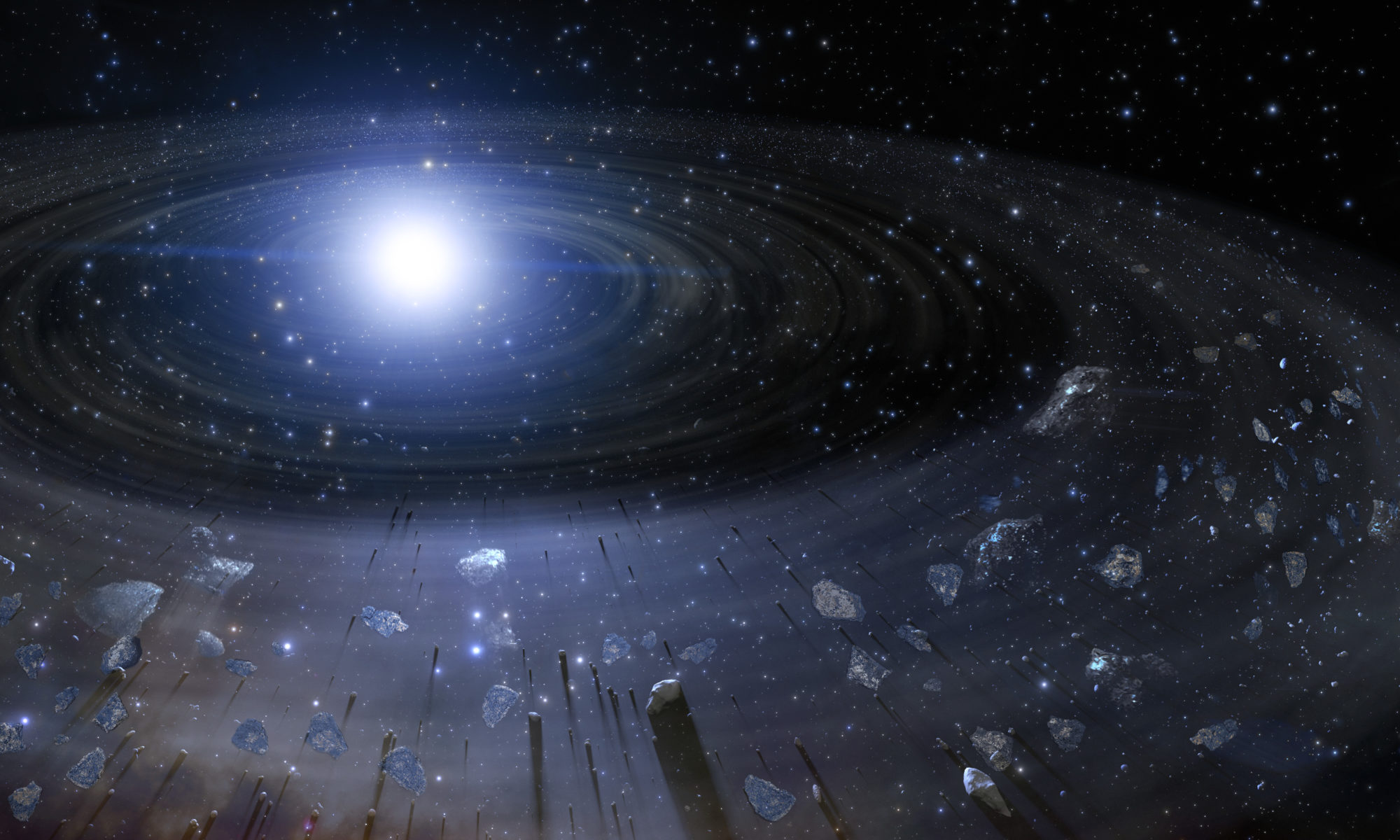
Featuring image: White dwarf make perfect natural mass spectrometer, more powerful as any instrument on Earth. Can they help us to learn about exoplanets? NOIRLab/NSF/AURA/J. da Silva, Creative Common (CC BY 4.0)

Paper: Polluted white dwarfs reveal exotic mantle rock types on exoplanets in our solar neighborhood

Authors: K. D. Putirka and S. Xu

For a long time, geologist were only able to study rocks on the ground. We extended this knowledge to our neighbouring planets. Now finally, scientist have found a way to study rocks from planets far away, using the light of their host stars. And they look very strange.

Over the last 30 years, exoplanets have evolved from mere theory into a fantastic reality. Today we know that nearly all stars host at least one exoplanet and even exoplanets with an Earth-like mass are relatively common. Still, we know very little about the geology of these worlds. In a new study, Keith Putirka and Siyi Xu were able to observe and compare the mineralogy of exoplanets to that of the rocky planets in the solar system. Surprisingly, these exoplanets exhibit types of mineralogy unlike any we have known before.

Continue reading “Do we need new types of geology to understand exoplanets?”

Mysteries of the deep (and bumpy) seafloor

Featured image: Elevation map of a seamount in the central Pacific, shown in a persepctive view. Image courtesy of the NOAA Office of Ocean Exploration and Research (public domain).

Paper: Fluid-rich subducting topography generates anomalous forearc porosity
Authors: Christine Chesley, Samer Naif, Kerry Key, Dan Bassett

Open any geology textbook, and you’re guaranteed to find a cartoon of a subduction zone showing how an incoming oceanic plate dives down beneath another tectonic plate (either continent or ocean) on its way back into Earth’s deep interior. These simple sketches typically show the top of the incoming plate as a smooth, gently curved line meeting and joining another smooth line at the base of the overriding plate – and that’s not exactly wrong, given the enormous scale of a subduction zone compared to the smallness of the drawing. But if you zoom in far enough on oceanic tectonic plates, the seafloor is often rough and bumpy. What happens, then, when rough seafloor heads into a subduction zone?

Continue reading “Mysteries of the deep (and bumpy) seafloor”

A New Paradigm in Decision Making?

A binary decision?

Paper: Quantifying Topological Uncertainty in Fractured Systems using Graph Theory and Machine Learning

Authors: Gowri Srinivasan, Jeffrey D. Hyman, David A. Osthus, Bryan A. Moore, Daniel O’Malley, Satish Karra, Esteban Rougier, Aric A. Hagberg, Abigail Hunter & Hari S. Viswanathan

Geophysics problems are as difficult as Nobel Prize-winning physics problems.

Dr. Jérõme A.R. Noir

This quote from Dr. Jérõme Noir has stayed with me throughout my career. The idea: while physicists face extreme math, but also have extremely precise data for unknown phenomena, geoscientists must find vital solutions for known phenomena using just a few data points on a planet. With very little data, how can complex problems in geoscience be solved? And, how do we assess the risk of being wrong? An uncertainty quantification framework recently developed by researchers at Los Alamos National Lab uses machine learning to help geoscientists arrive at quality decisions using limited data.

Continue reading “A New Paradigm in Decision Making?”

Geologists might have just solved a sixty year old Russian mystery

Featured image: Soviet authorities investigate a mangled tent involved in the Dyatlov Pass Incident. This work is in the public domain and is not an object of copyright according to article 1259 of Book IV of the Civil Code of the Russian Federation No. 230-FZ of December 18, 2006.

Paper: Gaume, J., Puzrin, A.M. Mechanisms of slab avalanche release and impact in the Dyatlov Pass incident in 1959. Commun Earth Environ 2, 10 (2021). https://doi.org/10.1038/s43247-020-00081-8

In 1959, a group of nine hikers led by Igor Dyatlov trekked through the Ural Mountains in Eastern Russia on a skiing trip. After no word by telegram from the hikers for eight days, their families grew nervous and demanded a search and rescue effort. Over two weeks after the hikers planned contact with their base camp, investigators located an abandoned and mangled tent on the slope of Kholat Syakhl (“Dead Hill” in the local dialect of Mansi). 

Continue reading “Geologists might have just solved a sixty year old Russian mystery”

Water in the rocky layer cake beneath us

Konza Prairie Biological Station

Featured Image: Konza Prairie near Manhattan, Kansas, USA. Credit: David Litwin.

Paper: Toward a new conceptual model for groundwater flow in merokarst systems: Insights from multiple geophysical approaches.

Authors: Sullivan, P. L., Zhang, C., Behm, M., Zhang, F., & Macpherson, G. L.

The dissolution of limestone by atmospheric water forms a set of recognizable features collectively known as karst: enormous caves with stalactites and stalagmites, sinkholes, chasms, and narrow, towering  columns of rock. The hydrology of karst landscapes is often incredibly complex, as water can flow rapidly through dissolution-formed conduits below ground, and topography offers fewer clues to groundwater flow than in most other landscapes. While dramatic karstic landscapes have received a lot of scientific attention, even smaller limestone units can host karst features that affect hydrology.

Continue reading “Water in the rocky layer cake beneath us”

Shaken, rattled, and rolled

Featured image: an aerial photograph of the Capitolias/Beit-Ras theater, courtesy of the Aerial Photographic Archive of Archaeology in the Middle East (APAAME), CC-BY-NC-ND 2.0

Paper: Two inferred antique earthquake phases recorded in the Roman theater of Beit-Ras/Capitolias (Jordan)
Authors: M. Al-Tawalbeh, R. Jaradat, K. Al-Bashaireh, A. Al-Rawabdeh, A. Gharaibeh, B. Khrisat, and M. Kázmér

One of the biggest questions in earthquake seismology is whether we can see into the future, to forecast seismic activity based on what we know about faults and how they behave. We’re about as likely to accurately predict earthquakes as we are to see the future in a crystal ball, but one way we can improve our forecasts of seismic hazard actually involves looking in the other direction: back into the past.

Continue reading “Shaken, rattled, and rolled”

Marsquakes give scientists an InSight to Mars

Featured image: An artist’s concept of NASA’s InSight lander on Mars with a cutaway of the surface below. Credit: IPGP/Nicolas Sarter.

Paper: Constraints on the shallow elastic and anelastic structure of Mars from InSight seismic data

Authors: Philippe Lognonné et al.,

Scientists are able to ‘see’ the internal structure of the Earth based on seismic waves recorded during Earthquakes. Earthquakes send seismic waves out in all directions with two main types: (1) surface waves are the major culprits of Earthquake damage as they remain on the surface; (2) faster body waves can travel down within Earth’s interior. The body waves are the fastest seismic waves, consisting of the first (primary; P-wave) and second (secondary, S-wave) waves to arrive at a location away from the epicentre of an Earthquake.

Continue reading “Marsquakes give scientists an InSight to Mars”

How do you break up a continent?

Featured image: Lake Malawi, as seen from space. Image courtesy of ESA/MERIS, CC-BY-SA IGO.

Paper: Preferential localized thinning of lithospheric mantle in the melt-poor Malawi Rift
Authors: E. Hopper, J. B. Gaherty, D. J. Shillington, N. J. Accardo, A. A. Nyblade, B. K. Holtzman, C. Havlin, C. A. Scholz, P. R. N. Chindandali, R. W. Ferdinand, G. D. Mulibo, G. Mbogoni

Continental rifting, where one landmass slowly breaks apart into two pieces separated by a brand new ocean basin, is a fundamental part of plate tectonics. But it presents an apparent paradox: the tectonic forces pulling on the plates are thought to be much too weak to break the strong rocks of the continents.

Continue reading “How do you break up a continent?”

Tiny wobbles foreshadow big earthquakes

Featured image: A GPS station in the Sawtooth National Forest near Ketchum, Idaho. Photo by Scott Haefner (USGS).

Paper: Months-long thousand-kilometre-scale wobbling before great subduction earthquakes
Authors: J. R. Bedford, M. Moreno, Z. Deng, O. Oncken, B. Schurr, T. John, J. C. Báez, M. Bevis

We’re always on the lookout for earthquake precursors, indicators that the Earth might be gearing up for some shaking, and geophysicists think they might have found a new one: a small but measurable back-and-forth “wobble” of the land starting several months before very big earthquakes hit.

Continue reading “Tiny wobbles foreshadow big earthquakes”

Climate records written on the seafloor

Featured image: A perspective view of the seafloor at the East Pacific Rise, 9N. Made with GeoMapApp (www.geomapapp.org, CC-BY), and GMRT topography data (Ryan et al. 2009, CC-BY).

Paper: Do sea level variations influence mid-ocean ridge magma supply? A test using crustal thickness and bathymetry data from the East Pacific Rise
Authors: B. Boulahanis, S. M. Carbotte, P. J. Huybers, M. R. Nedimovic, O. Aghaei, J. P. Canales, and C. H. Langmuir

Many of our records of past sea level come from local measurements from coastal towns logged over decades or centuries, or are estimated from ice or sediment cores spanning the last few thousand years, but new research suggests that much longer records can be found in an unlikely place: imprinted deep underground in the oceanic crust.

Continue reading “Climate records written on the seafloor”