Water under Fire

A small, orange-brown lake is set in a deep crater of grey-brown rock

Paper: Modeling Groundwater Inflow to the New Crater Lake at K¯ılauea Volcano, Hawai’i

Authors: SE Ingebritsen, AF Flinders, JP Kauahikaua, and PA Hsieh

Accompaniment to the Third Pod from the Sun episode

When we think of opposing forces in the natural world, fire and water come quickly to mind; elemental powers always at odds, one winning out over the other. There are a few interesting times and places, though, where they can co-exist, occupying some of the same spaces in the landscape.  Perhaps the most visible example of these in the geological world are hydrothermal systems in volcanically active regions, places where earth’s internal heat meets subterranean water with, at times, explosive results.    

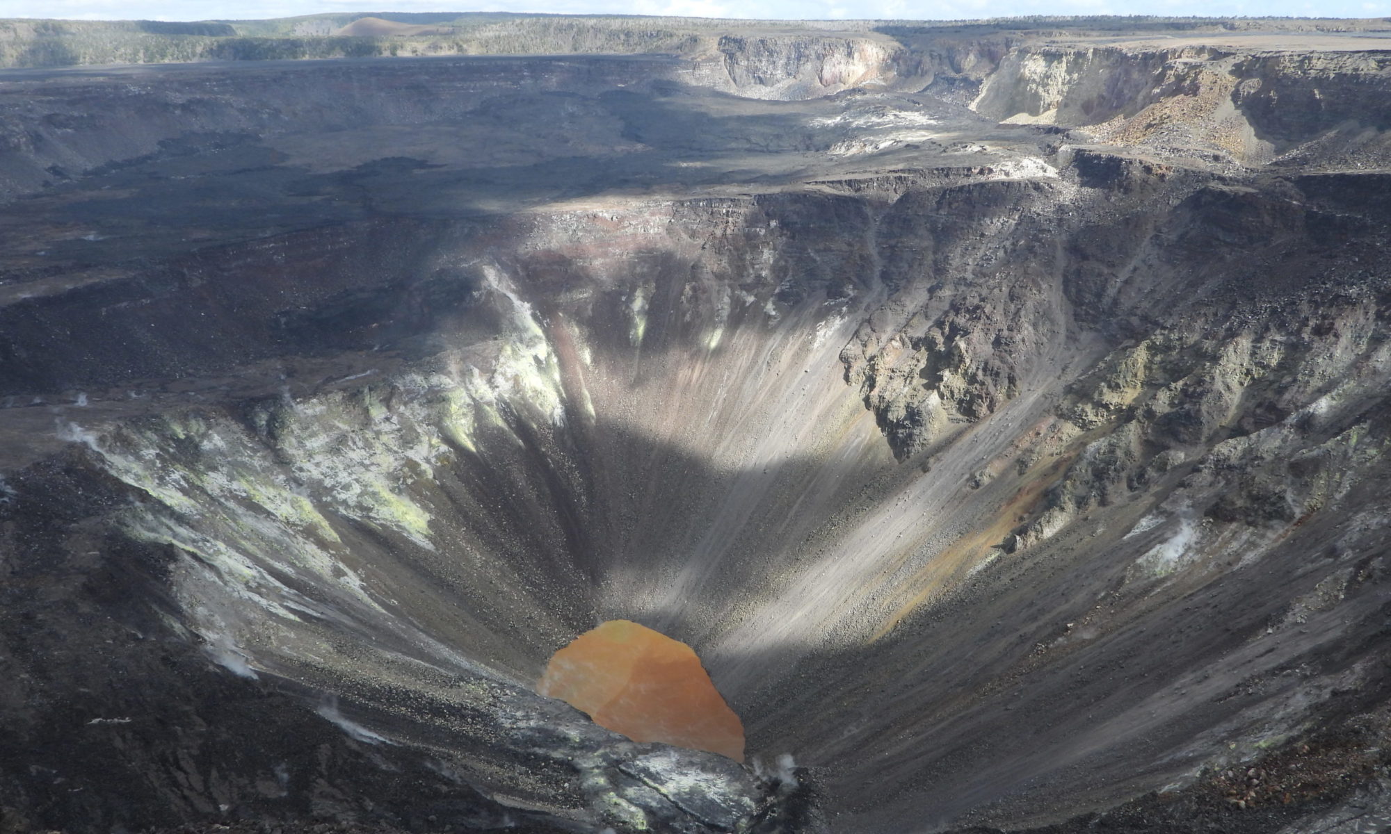
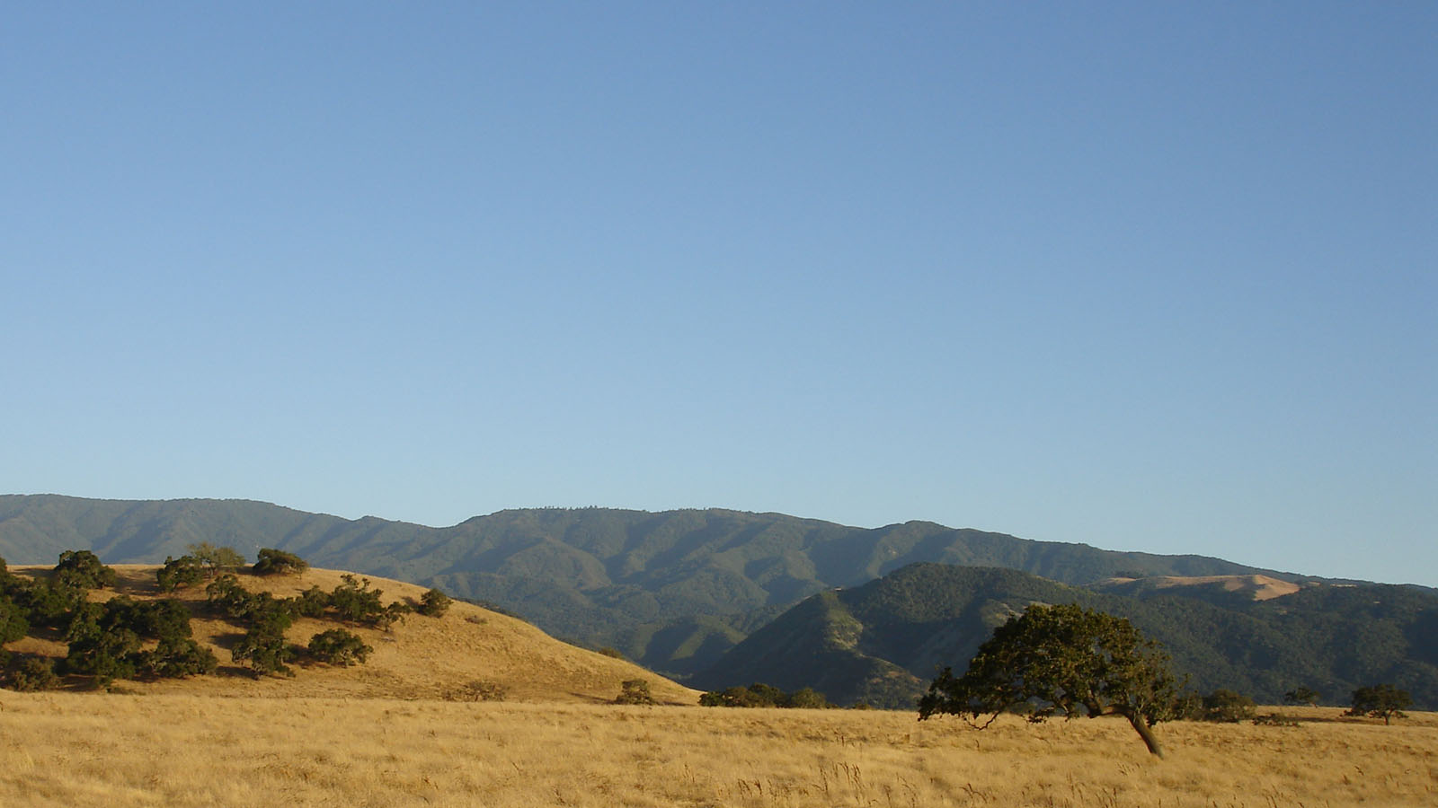
For decades the crater at the summit of the Kilauea volcano in Hawai’i, one of the world’s most active volcanoes, was filled with a pool of lava. The constant flow of magma churning up from the volcano’s depths kept this lava lake supplied with fresh molten material.  

That is, until a major eruption in 2018 shifted the volcanic pipelines beneath the lake causing it to empty dramatically at the same time major fissure eruptions were sending waves of lava over residential areas near the eastern flank of the mountain. When a now-empty summit crater began to fill with water, no one was quite sure what to expect.  

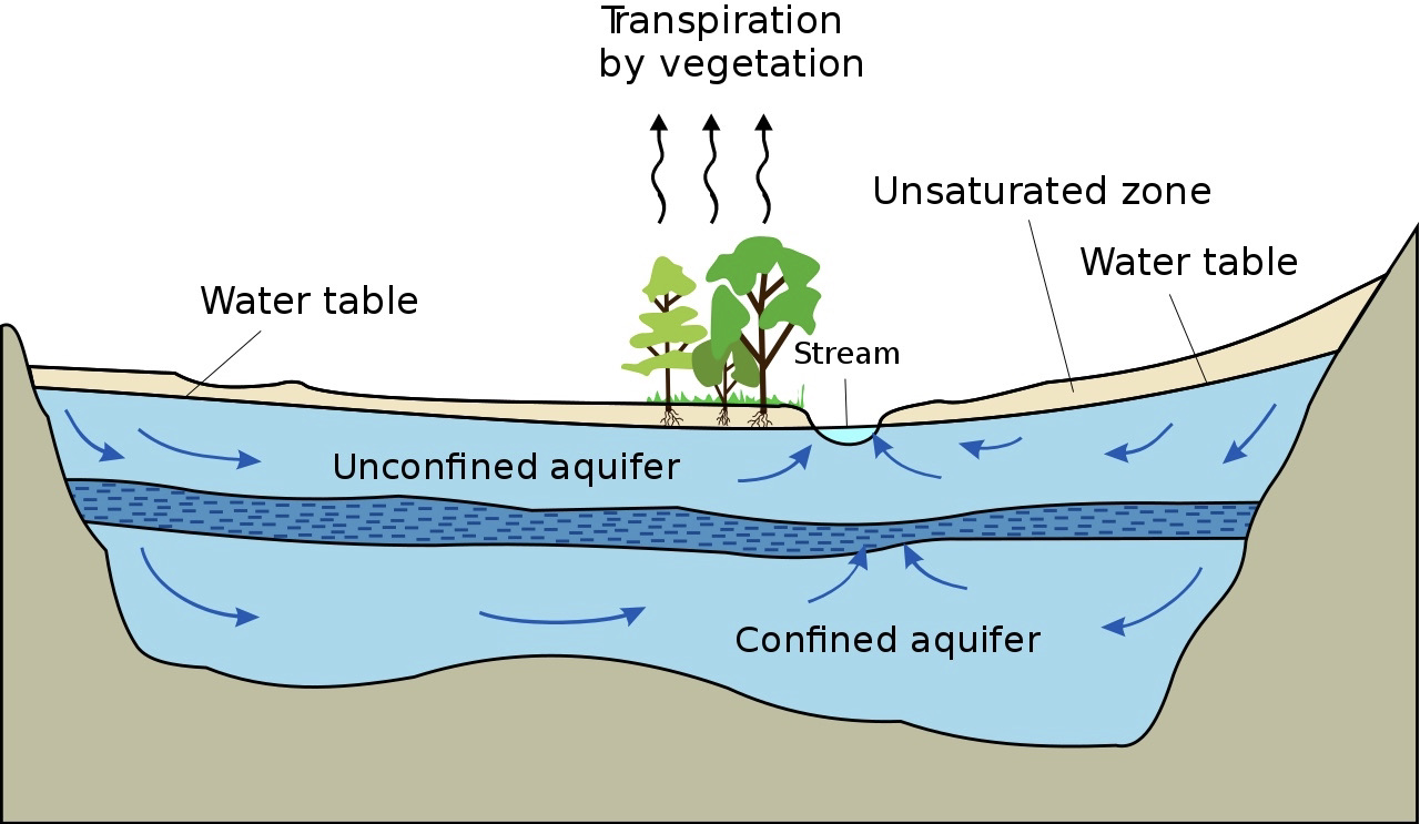
Eruptions at Kilauea have been frequent occurrences over the last at least 200 years with varying frequency and intensity. Some of these events have led to what geologists call ‘phreatic eruptions’, highly explosive events that occur when erupting lava comes in contact with cold water causing a high energy eruption of steam, ash, and rock fragments. Often in Hawai’i this occurs when lava flows reach the ocean; however, in the 2018 eruption, groundwater posed a new concern. When the lava lake at the summit began to drop below the water table, both water and lava were essentially trying to fill in the same spaces. At that point there was speculation that some highly explosive events could be imminent as the lava reached the groundwater table and larger volumes of water began to flow into the crater. Relatively little was known about the groundwater table in the area and how long it would take to fill the now empty lakebed emptied of lava. 

Researchers from the U.S. Geological Survey (USGS) hurried to develop new conceptual and numerical computer models to predict how the balance between lava flow and groundwater flow would shift as these internal conduits in the mountain emptied of molten material and began to fill with water. The groundwater flow models were challenged by the temperatures and pressures involved in the Kilauea scenario and initial predictions ranging from 3 to 24 months were narrowed as the lake began to fill in July of 2019, about 14 months after the lava lake collapse. In a paper in the journal Groundwater they explain how water flow was delayed by many months by the inability of groundwater to move through the extremely hot rock. New observations of on the ground conditions, such as inflow, temperature, and evaporation rates helped to refine the existing model to better understand the potential for future interactions in the crater and give volcano observers better tools to predict these potentially hazardous magma-water interactions in future eruptions. 


Water under Fire by Avery Shinneman is licensed under a Creative Commons Attribution-ShareAlike 4.0 International License.

Our enduring fascination with groundwater springs

Landscape with mountains in the distance and trees, rocks, and a path in the foreground

Featured Image: The middle zone of the Gerecse Mountains in Hungary via Wikimedia Commons. Public Domain.

Article: Springs regarded as hydraulic features and interpreted in the context of basin-scale groundwater flow
Authors:
Tóth, Á., Kovács, S., Kovács, J., & Mádl-Szőnyi, J.

O Fount Bandusia, brighter than crystal,
worthy of sweet wine and flowers,
tomorrow shalt thou be honoured with
a firstling of the flock whose brow,

with horns just budding, foretokens love
and strife. Alas! in vain; for this
offspring of the sportive flock shall
dye thy cool waters with its own red blood.

Thee the fierce season of the blazing
dog-star cannot touch; to bullocks wearied
of the ploughshare and to the roaming flock
thou dost offer gracious coolness.

Thou, too, shalt be numbered among the
far-famed fountains, through the song I
sing of the oak planted o’er the grotto
whence thy babbling waters leap.

Horace (56BC-8BC) Ode 3.13

This ode by the Roman poet Horace is part of a long tradition of art and literature honoring groundwater springs, called ‘founts’ or ‘fountains’ in this translation. It is no wonder why: they can provide high-quality water that continues to flow even in the heat of a Mediterranean summer, “the fierce season of the blazing dog-star,” when surface water is often not available. But where does this water come from? Is it from large underground lakes, as the Romans suspected? Some of the same characteristics Horace names in this poem can help scientists figure this out.

Continue reading “Our enduring fascination with groundwater springs”

Pipe Dreams: stories of Bengaluru’s water supply

Featured Image: Raj Bhagatt P (published with permission from the author)

Castán Broto, V., Sudhira, H. and Unnikrishnan, H. (2021), WALK THE PIPELINE: Urban Infrastructure Landscapes in Bengaluru’s Long Twentieth Century. Int. J. Urban Reg. Res., 45: 696-715. https://doi.org/10.1111/1468-2427.12985

Can a pipeline that runs through an urban landscape weave narratives of water usage through space and time? A beautiful article published in the International Journal of Urban and Regional Research captures some of the stories along the oldest pipeline in Bengaluru, South India. The narratives talk of the urban and rural divide, the patterns of urban sprawl, the pre-colonial water management, and the scarcity faced today.

Before the pipeline, Bengaluru relied on an ancient network of seasonally-replenished tanks, reservoirs and open wells for its agrarian water supply. This network was engineered to harness the natural gradients of Bengaluru’s topography, and to ensure water reached different parts of the city. In 1894, the Chamarajendra waterworks laid down the first modern iron pipeline to source water from the Arkavathi river to Bengaluru’s colonial heart – and history was made. Based on old planning records and an analysis of historic maps, this pipeline today can be traced from the low-level reservoir at the heart of Bengaluru, passing through the neighbourhoods of Malleshwaram, Yeshwanthpur, and Dasarahalli, ending at the Hesaraghatta tank at the northwest corner of the city. Throughout history, the pipeline has affected the lives of people and other urban infrastructure along the way, and continues to do so.

Landmarks along the oldest pipeline in Bengaluru today. Image credits: H.S. Sudhira. Image source: https://doi.org/10.1111/1468-2427.12985

In the 1960s, the Bangalore Water Supply and Sewerage Board (BWSSB) was created to meet the demands of the city. Yet with the ever-expanding urban stretches and the burgeoning population, water scarcity is among the major challenges faced by Bengaluru today. Pipelines from Tarabanahalli, and from Shivanasamudra, along with the old one from Hesaraghatta, transfer water from the rural outskirts to the heart of Bengaluru. In addition, groundwater resources and some water from the Arkavathi river is carried by tankers into the city, to supplement the 6,000 public borewells, and roughly 50,000 residential borewells. Despite water conservation efforts like rainwater harvesting and recycling, the water scarcity in Bengaluru has begun to have ecological and environmental impacts – and the impact will be disproportionately felt by the low-income groups, who can not afford private borewells, nor the cost of long-distance transfers.

A 1914 map of Bengaluru by Baedekar showing some of the old tanks in the heart of the city. In the colonial era, as a cantonment, tanks and wells served much of the city’s water demands. Image: public domain.

The article goes on to reflect on the historical, socio-economic, and political aspects of the neighbourhoods through which the pipeline flows – almost like a travelogue with a bitter note. As the pipeline networks developed, they created a set of conditions for residential and industrial development. Some neighbourhoods benefit directly from the pipeline, whereas some don’t, and over time the pipeline has further marginalized the poorer populations from receiving a good supply of water. These disparities will only get starker in the years to come. Residential overcrowding, land misappropriation, pollution, and increasing demand for industry and residences affect the efficiency of the water network and strain the groundwater resources. As more technological solutions are sought, the local ecologies that sustained these past water systems – such as agricultural patches that helped replenish tanks, the numerous rainwater-filled lakes that have since disappeared due to encroachment, or are severely polluted and littered, have been ignored.

The article underlines a harsh truth – Bengaluru never had enough water. If we are to strategize our water infrastructures again, we need new technological approaches, new resources or to reverse the direction of services from the peri-urban area to the centre of the city and vice versa, with due cognizance of encroachment and violations by existing and future development. The traditional system of tanks and wells needs to be integrated into the broader network of water resources to meet the needs of an ever-expanding urban nexus.


Pipe Dreams: stories of Bengaluru’s water supply by Devayani Khare is licensed under a Creative Commons Attribution-ShareAlike 4.0 International License.

What can a delta’s history tell us about groundwater’s future?

Feature image: Mosiac of the the Ganges Delta in false color created with imagery from the Sentinal 2 satilite. CC-By Annamaria Luongo, via Wikimedia Commons


Article: Linking the Surface and Subsurface in River Deltas—Part 2: Relating Subsurface Geometry to Groundwater Flow Behavior
Authors: Xu, Z., Hariharan, J., Passalacqua, P., Steel, E., Paola, C., & Michael, H. A.

Deltas are striking features on Earth’s surface, where rivers meet large water bodies. Their flow spreads out into many channels, depositing the sediment they have been carrying, potentially since their headwaters. This sediment creates and sustains the delta, which can be hundreds of miles across. Beyond being mesmerizing, deltas are essential to human civilization, past and present. Nearly half a billion people live on deltas around the world, where the deposited sediment hosts some of the most fertile agricultural land available.

Continue reading “What can a delta’s history tell us about groundwater’s future?”

A New Paradigm in Decision Making?

A binary decision?

Paper: Quantifying Topological Uncertainty in Fractured Systems using Graph Theory and Machine Learning

Authors: Gowri Srinivasan, Jeffrey D. Hyman, David A. Osthus, Bryan A. Moore, Daniel O’Malley, Satish Karra, Esteban Rougier, Aric A. Hagberg, Abigail Hunter & Hari S. Viswanathan

Geophysics problems are as difficult as Nobel Prize-winning physics problems.

Dr. Jérõme A.R. Noir

This quote from Dr. Jérõme Noir has stayed with me throughout my career. The idea: while physicists face extreme math, but also have extremely precise data for unknown phenomena, geoscientists must find vital solutions for known phenomena using just a few data points on a planet. With very little data, how can complex problems in geoscience be solved? And, how do we assess the risk of being wrong? An uncertainty quantification framework recently developed by researchers at Los Alamos National Lab uses machine learning to help geoscientists arrive at quality decisions using limited data.

Continue reading “A New Paradigm in Decision Making?”

Wet Feet? No problem: sandy humid forests grow best with access to groundwater

Pine forest in Governor Thompson State Park, WI, USA

Feature Image: Pine forest in Governor Thompson State Park, WI, USA. Yinan Chen, Public Domain, via Wikimedia Commons

Article: Groundwater subsidizes tree growth and transpiration in sandy humid forests
Authors: D. M. Ciruzzi and S. P. Loheide

Drought is often in the news these days, especially in places with arid and semi-arid climates where water is already scarce. While ecosystems have adapted over millennia to cope with dry climates and seasonal droughts, the increasing intensity and frequency of drought due to climate change and human demand for water can pose significant threats to ecosystem health and survival.

Continue reading “Wet Feet? No problem: sandy humid forests grow best with access to groundwater”

Water in the rocky layer cake beneath us

Konza Prairie Biological Station

Featured Image: Konza Prairie near Manhattan, Kansas, USA. Credit: David Litwin.

Paper: Toward a new conceptual model for groundwater flow in merokarst systems: Insights from multiple geophysical approaches.

Authors: Sullivan, P. L., Zhang, C., Behm, M., Zhang, F., & Macpherson, G. L.

The dissolution of limestone by atmospheric water forms a set of recognizable features collectively known as karst: enormous caves with stalactites and stalagmites, sinkholes, chasms, and narrow, towering  columns of rock. The hydrology of karst landscapes is often incredibly complex, as water can flow rapidly through dissolution-formed conduits below ground, and topography offers fewer clues to groundwater flow than in most other landscapes. While dramatic karstic landscapes have received a lot of scientific attention, even smaller limestone units can host karst features that affect hydrology.

Continue reading “Water in the rocky layer cake beneath us”

The Fate of Aquifers, and What Controls It

Paper: Divergent effects of climate change on future groundwater availability in key mid-latitude aquifers

Authors: Wen-Ying Wu, Min-Hui Lo, Yoshihide Wada, James S. Famiglietti, John T. Reager, Pat J.-F. Yeh, Agnès Ducharne, and Zong-Liang Yang

The ground I’m standing on feels solid, but it’s really full of porous rocks. The holes in these rocks are all different sizes, and water can flow through and between those with larger holes. Together, bodies of rocks that are saturated with water form aquifers. As groundwater supplies more than a third of the water humans use, groundwater and the aquifers that contain it are vital. They are especially vital in mid-latitude arid and semi-arid regions without enough surface water. In their recent research, Wen-Ying Wu and their collaborators studied the future of aquifers in such regions and what factors control it.

Continue reading “The Fate of Aquifers, and What Controls It”

Looking below ground for secrets to drought resilience

Santa Ynez Mountains

Featured image: Oak savanna near the Santa Ynez mountains in California. Clyde Frogg, public domain.

Paper: Low Subsurface Water Storage Capacity Relative to Annual Rainfall Decouples Mediterranean Plant Productivity and Water Use From Rainfall Variability

Authors: Hahm, W. J., Dralle, D. N., Rempe, D. M., Bryk, A. B., Thompson, S. E., Dawson, T. E., & Dietrich, W. E.

Between 2011 and 2016, a severe drought killed over 100 million trees in California. However, not all places responded to this drought in the same way. In some locations, trees and other plants seemed hardly affected, while in other places mortality was widespread. What caused this difference? In a 2019 study, Hahm and colleagues explored the role that water storage in ecosystems has on their resilience to drought. With extreme droughts becoming more common due to climate change, understanding why certain areas are more vulnerable is important for making predictions and improving forest management.

Continue reading “Looking below ground for secrets to drought resilience”

Do Microbes Release Fluorine from Rocks?

Image of soil microcosm

Featured Image used with permission of photographer (Cassi Wattenburger)

Paper: Indigenous microbes induced fluoride release from aquifer sediments

Authors: Xubo Gao, Wenting Luo, Xuesong Luo, Chengcheng Li, Xin Zhang, Yanxin Wang

My science textbook taught me that fluorine (F) was really important for dental health, and I’ve since learned that both excessive and insufficient amounts of fluoride in groundwater can cause health issues. While the chemistry behind the release of fluoride ions from rocks or sediments into groundwater is well understood, the microbiology of this process is not. Specifically, scientists have been wondering whether microbes could speed up the release of F from sediments into groundwater. 

Continue reading “Do Microbes Release Fluorine from Rocks?”