How does smoke from wildfires in the western U.S. change the regional climate?

Feature image from Pixabay

Article: Biomass Burning Smoke and Its Influence on Clouds Over the Western U. S.

Authors: C. H. Twohy, D. W. Toohey, E. J. T. Levin, P. J. DeMott, B. Rainwater, … & E. V. Fischer

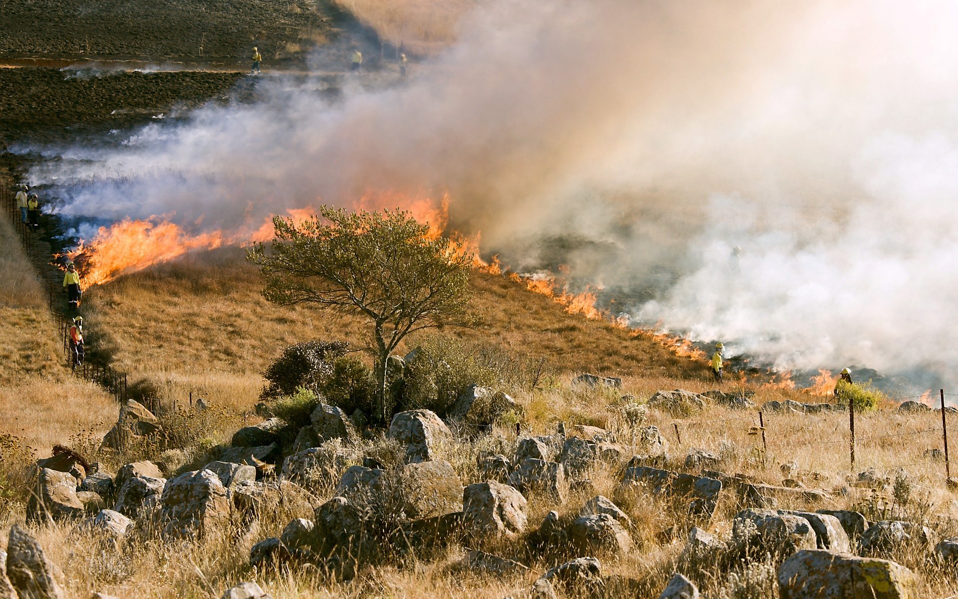
The area burned by wildfires has been increasing in the western U.S. in recent years and is expected to continue to increase due to climate change. In fact, a large wildfire is currently burning in Sequoia National Park in California, threatening to impact some of the largest and oldest living trees in the world. While wildfires directly impact people, wildlife, and the environment in many ways, a lesser-known impact, involving clouds, can influence the regional weather and climate.

Continue reading “How does smoke from wildfires in the western U.S. change the regional climate?”

How does climate change impact extreme cold outbreaks in the United States?

Featured image from CJ on Pixabay

Article: Quantifying Human-Induced Dynamic and Thermodynamic Contributions to Severe Cold Outbreaks Like November 2019 in the Eastern United States
Authors: C. Zhou, A. Dai, J. Wang, and D. Chen

Questions about extreme cold outbreaks have been featured in the U.S. news recently, as a majority of the country experienced record-breaking cold temperatures during the week of February 8, 2021. Was this extreme cold related to climate change? Will we see more of these events in the future? As Texans faced extensive blackouts due to issues with electricity generation and transmission because of the cold, meteorologists and news reporters tried to answer these questions as best they could. But what does the latest climate science say about the link, if any, between extreme cold outbreaks and climate change?

Continue reading “How does climate change impact extreme cold outbreaks in the United States?”

Satellite Technology Helps Discover New Weather Phenomena: Lightning Megaflashes

Featured Image from Bethany Laird on Unsplash

Paper: Where are the Most Extraordinary Lightning Megaflashes in the Americas?

Author: Michael Peterson

Most lightning flashes only last 0.2 seconds, meaning if you blink at the wrong moment, you could miss it. However, scientists have developed new lightning-detection instruments, known as Geostationary Lightning Mappers (GLMs), that never miss a flash. The GLMs are aboard the two Geostationary Operational Environmental Satellites (GOES-West and GOES-East), which are in stationary orbits over the Earth’s western hemisphere. With the data from the GLMs, atmospheric scientists have discovered new lightning phenomena called “megaflashes” which can light up the sky for as long as 16 seconds.

Continue reading “Satellite Technology Helps Discover New Weather Phenomena: Lightning Megaflashes”

North Atlantic Ice Melt May Increase the Storminess of the Northern Hemisphere

Featured image of sea ice from Free-Photos on Pixabay

Paper: Rapid Cooling and Increased Storminess Triggered by Freshwater in the North Atlantic
Authors: M. Oltmanns, J. Karstensen, G. W. K. Moore, and S. A. Josey

Way up north in the Arctic Circle, sea ice and glaciers are rapidly melting and sending a massive amount of cold, fresh water into the North Atlantic Ocean. At first this influx of cold water may seem beneficial to offset the warming from climate change, but new research suggests that this meltwater from Greenland and the Arctic increases the number of winter storms that occur in the Northern Hemisphere.

Continue reading “North Atlantic Ice Melt May Increase the Storminess of the Northern Hemisphere”

We’re Not in Kansas Anymore: Documenting Historical Tornadoes in Northern Eurasia

Feature image: “Tornado Alley” by Nikolas Noonan on unsplash.com (https://unsplash.com/photos/n_3kdpSkrJo)

Paper: Tornadoes in Northern Eurasia: From the Middle Age to the Information Era
Authors: A. Chernokulsky, M. Kurgansky, I. Mokhov, A. Shikhov, I. Azhigov, E. Selezneva, D. Zakharchenko, B. Antonescu, and T. Kühne

When most people are asked to picture a tornado in their mind, they probably imagine the violent column of swirling wind and debris tearing through an open field in rural Kansas, as depicted in the classic 1939 film The Wizard of Oz. However, while the United States Midwest, so-called “Tornado Alley”, is the most well-known tornado hot-spot in the world, tornadoes touch down on every continent except Antarctica. A recent study by Chernokulsky and his team has established a comprehensive history of tornadoes that have occurred in an area commonly neglected in tornado research: northern Eurasia.

Continue reading “We’re Not in Kansas Anymore: Documenting Historical Tornadoes in Northern Eurasia”

How does dust from African and Asian deserts affect rainfall over California?

Featured image: Sand Dunes by Free-Photos on Pixabay

Paper: Dusty Atmospheric Rivers: Characteristics and Origins

Authors: Kara K. Voss, Amato T. Evan, Kimbery A. Prather, and F. Martin Ralph

Atmospheric rivers, narrow plumes of highly concentrated water vapor in the atmosphere, can cause heavy rain over the coastal western United States and southwest Canada. In fact, up to half of California’s annual rainfall comes from atmospheric rivers, and while this rain helps replenish California’s water sources, it can also cause flooding and mudslides. A new study sheds light on how dust kicked up from deserts halfway around the world in Africa and Asia may influence these atmospheric rivers and control California’s rain patterns.

Continue reading “How does dust from African and Asian deserts affect rainfall over California?”