Shaken, rattled, and rolled

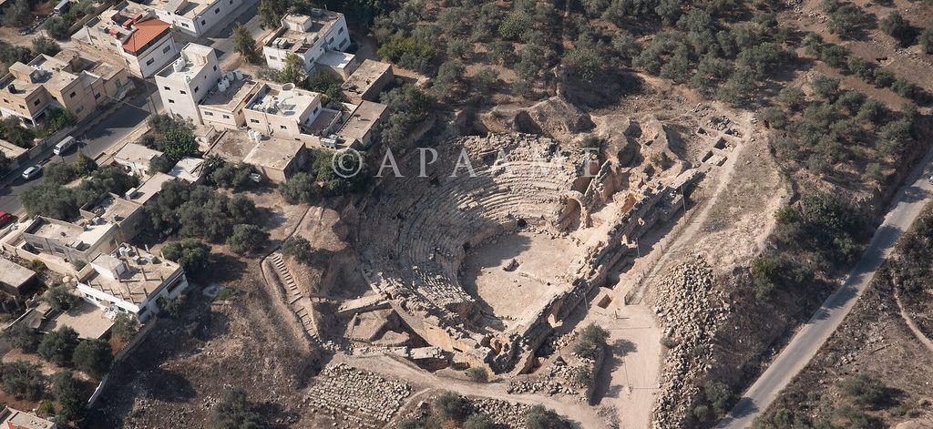
Featured image: an aerial photograph of the Capitolias/Beit-Ras theater, courtesy of the Aerial Photographic Archive of Archaeology in the Middle East (APAAME), CC-BY-NC-ND 2.0

Paper: Two inferred antique earthquake phases recorded in the Roman theater of Beit-Ras/Capitolias (Jordan)
Authors: M. Al-Tawalbeh, R. Jaradat, K. Al-Bashaireh, A. Al-Rawabdeh, A. Gharaibeh, B. Khrisat, and M. Kázmér

One of the biggest questions in earthquake seismology is whether we can see into the future, to forecast seismic activity based on what we know about faults and how they behave. We’re about as likely to accurately predict earthquakes as we are to see the future in a crystal ball, but one way we can improve our forecasts of seismic hazard actually involves looking in the other direction: back into the past.

Continue reading “Shaken, rattled, and rolled”

Satellite Technology Helps Discover New Weather Phenomena: Lightning Megaflashes

Featured Image from Bethany Laird on Unsplash

Paper: Where are the Most Extraordinary Lightning Megaflashes in the Americas?

Author: Michael Peterson

Most lightning flashes only last 0.2 seconds, meaning if you blink at the wrong moment, you could miss it. However, scientists have developed new lightning-detection instruments, known as Geostationary Lightning Mappers (GLMs), that never miss a flash. The GLMs are aboard the two Geostationary Operational Environmental Satellites (GOES-West and GOES-East), which are in stationary orbits over the Earth’s western hemisphere. With the data from the GLMs, atmospheric scientists have discovered new lightning phenomena called “megaflashes” which can light up the sky for as long as 16 seconds.

Continue reading “Satellite Technology Helps Discover New Weather Phenomena: Lightning Megaflashes”

We’re Not in Kansas Anymore: Documenting Historical Tornadoes in Northern Eurasia

Feature image: “Tornado Alley” by Nikolas Noonan on unsplash.com (https://unsplash.com/photos/n_3kdpSkrJo)

Paper: Tornadoes in Northern Eurasia: From the Middle Age to the Information Era
Authors: A. Chernokulsky, M. Kurgansky, I. Mokhov, A. Shikhov, I. Azhigov, E. Selezneva, D. Zakharchenko, B. Antonescu, and T. Kühne

When most people are asked to picture a tornado in their mind, they probably imagine the violent column of swirling wind and debris tearing through an open field in rural Kansas, as depicted in the classic 1939 film The Wizard of Oz. However, while the United States Midwest, so-called “Tornado Alley”, is the most well-known tornado hot-spot in the world, tornadoes touch down on every continent except Antarctica. A recent study by Chernokulsky and his team has established a comprehensive history of tornadoes that have occurred in an area commonly neglected in tornado research: northern Eurasia.

Continue reading “We’re Not in Kansas Anymore: Documenting Historical Tornadoes in Northern Eurasia”

Pioneering plants tell us when volcanoes last erupted

Featured image: vegetated lava flows on Le Grand Brûlé, with the profile of Piton de la Fournaise behind. Image credit: Mickaël Douineau on Flickr (CC BY-NC-ND 2.0).

Paper : Dating young (<1000 yr) lava flow eruptions of Piton de la Fournaise volcano from size distribution of long-lived pioneer trees Authors: Sébastien Albert, Olivier Flores, Laurent Michon and Dominique Strasberg

A newly formed lava flow may appear to be a sterile environment: devoid of vegetation and humus. But within years, the rocky wasteland erupts into life as a host of tenacious plants take hold. The size of plants rooted on solidified lava is now being used by volcanologists working on Piton de la Fournaise, a shield volcano on the Indian Ocean island of Réunion, to date past eruptions.

Continue reading “Pioneering plants tell us when volcanoes last erupted”

Tiny wobbles foreshadow big earthquakes

Featured image: A GPS station in the Sawtooth National Forest near Ketchum, Idaho. Photo by Scott Haefner (USGS).

Paper: Months-long thousand-kilometre-scale wobbling before great subduction earthquakes
Authors: J. R. Bedford, M. Moreno, Z. Deng, O. Oncken, B. Schurr, T. John, J. C. Báez, M. Bevis

We’re always on the lookout for earthquake precursors, indicators that the Earth might be gearing up for some shaking, and geophysicists think they might have found a new one: a small but measurable back-and-forth “wobble” of the land starting several months before very big earthquakes hit.

Continue reading “Tiny wobbles foreshadow big earthquakes”

Small Sediment’s Big Impact on Flash Floods

Featured image by Hans from Pixabay.

Paper: Modeling the Effects of Sediment Concentration on the Propagation of Flash Floods in an Andean Watershed

Authors: María Teresa Contreras and Cristían Escauriaza

Climate change has altered weather patterns around the world and has even led to increased heavy rainfall in some regions.  This, combined with El Niño – a weather pattern produced by unusual winds that can cause some regions to experience heavier than normal rainfall – has led to high numbers of catastrophic flash floods in populated areas near the Andes mountains.  To add insult to injury, climate models predict increases in heavy rainfall events in the future, further worsening the chance for flash floods. New research from scientists working in Chile and the United States aims to model the impact of these floods on communities by simulating realistic flash flood conditions with different amounts of sediment, a potentially dangerous component of flash floods in mountainous regions.

Continue reading “Small Sediment’s Big Impact on Flash Floods”

How to locate oceanic earthquakes without getting your feet wet

Photo of a fence offset by fault slip on the San Andreas during the 1906 San Francisco earthquake

Featured image: A fence broken by the 1906 San Francisco earthquake, by G. K. Gilbert. Public domain.

For the millions of people living near the San Andreas fault zone in California, the billion-dollar question is when the next “big one” is going to happen.

Continue reading “How to locate oceanic earthquakes without getting your feet wet”

What Caused the Flood that (Possibly) Gave Rise to an Empire?

Featured image: The Yellow River Breaches its Course by Ma Yuan, Public Domain

Paper: Uranium isotopic constraints on the nature of the prehistoric flood at the Lajia site, China
Authors: Le Li, Jun Chen, David William Hedding, Yuanhe Fu, Maolin Ye, Gaojun Li

A small sand deposit might hold the key to dating the rise of China’s first dynasty. Continue reading “What Caused the Flood that (Possibly) Gave Rise to an Empire?”