Pipe Dreams: stories of Bengaluru’s water supply

Featured Image: Raj Bhagatt P (published with permission from the author)

Castán Broto, V., Sudhira, H. and Unnikrishnan, H. (2021), WALK THE PIPELINE: Urban Infrastructure Landscapes in Bengaluru’s Long Twentieth Century. Int. J. Urban Reg. Res., 45: 696-715. https://doi.org/10.1111/1468-2427.12985

Can a pipeline that runs through an urban landscape weave narratives of water usage through space and time? A beautiful article published in the International Journal of Urban and Regional Research captures some of the stories along the oldest pipeline in Bengaluru, South India. The narratives talk of the urban and rural divide, the patterns of urban sprawl, the pre-colonial water management, and the scarcity faced today.

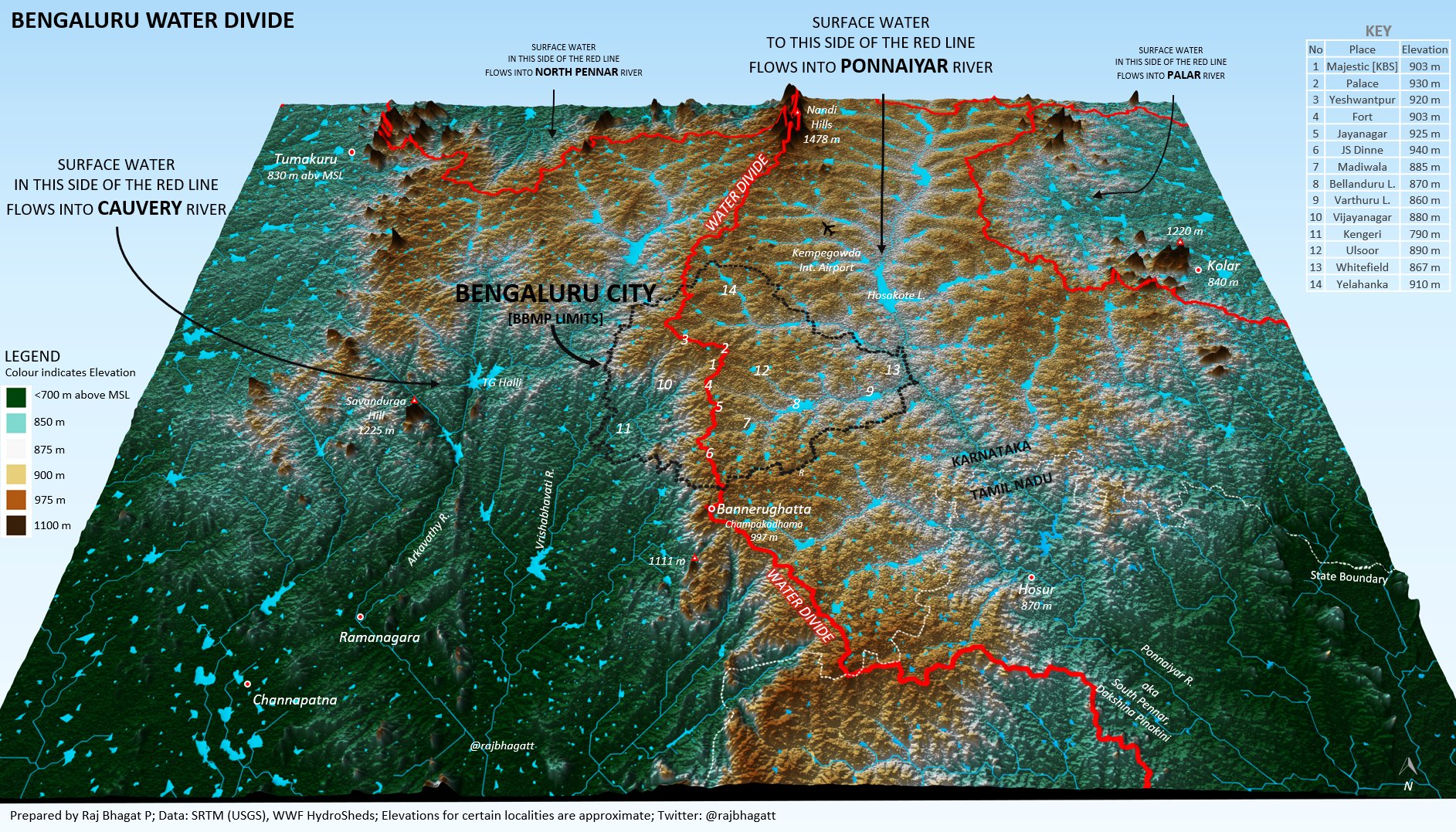
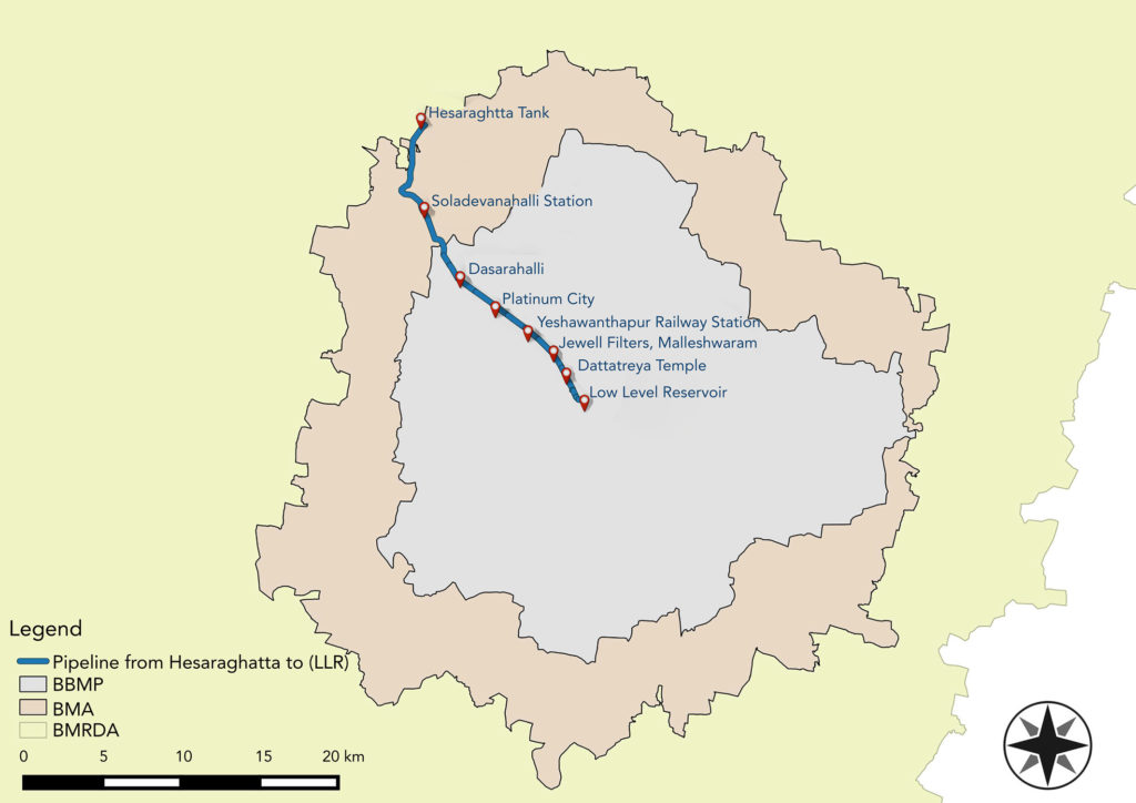
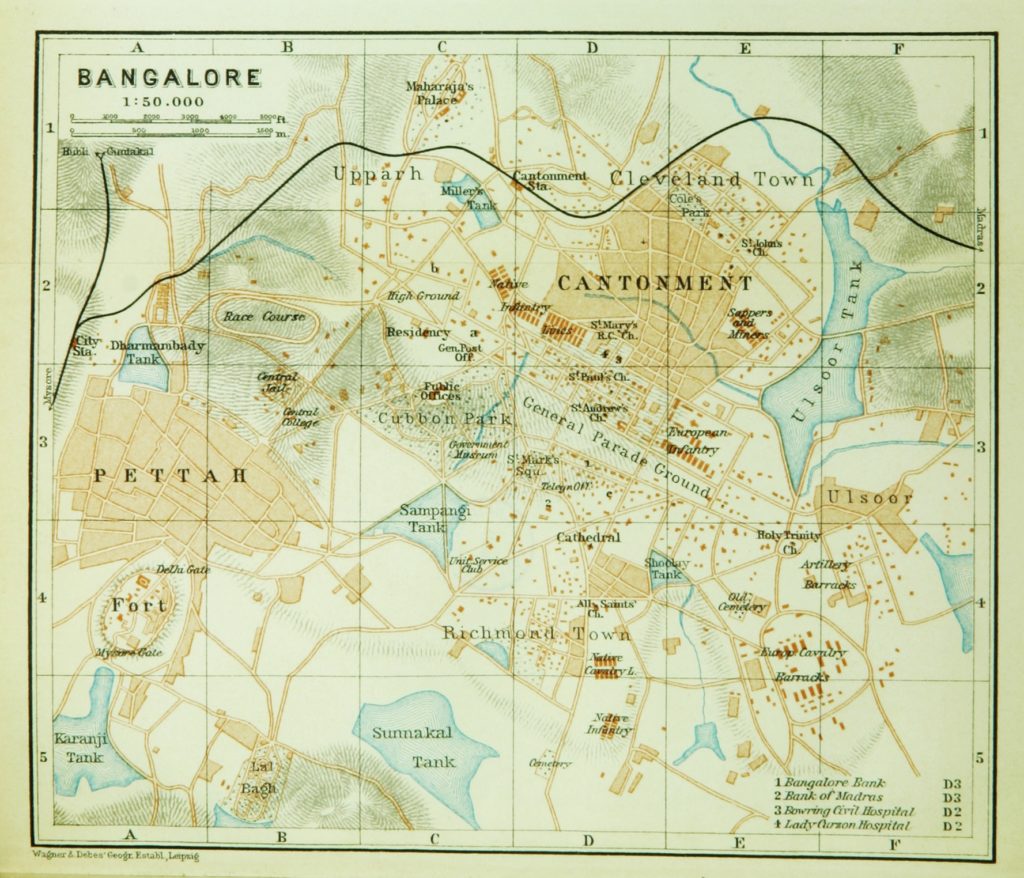
Before the pipeline, Bengaluru relied on an ancient network of seasonally-replenished tanks, reservoirs and open wells for its agrarian water supply. This network was engineered to harness the natural gradients of Bengaluru’s topography, and to ensure water reached different parts of the city. In 1894, the Chamarajendra waterworks laid down the first modern iron pipeline to source water from the Arkavathi river to Bengaluru’s colonial heart – and history was made. Based on old planning records and an analysis of historic maps, this pipeline today can be traced from the low-level reservoir at the heart of Bengaluru, passing through the neighbourhoods of Malleshwaram, Yeshwanthpur, and Dasarahalli, ending at the Hesaraghatta tank at the northwest corner of the city. Throughout history, the pipeline has affected the lives of people and other urban infrastructure along the way, and continues to do so.

Landmarks along the oldest pipeline in Bengaluru today. Image credits: H.S. Sudhira. Image source: https://doi.org/10.1111/1468-2427.12985

In the 1960s, the Bangalore Water Supply and Sewerage Board (BWSSB) was created to meet the demands of the city. Yet with the ever-expanding urban stretches and the burgeoning population, water scarcity is among the major challenges faced by Bengaluru today. Pipelines from Tarabanahalli, and from Shivanasamudra, along with the old one from Hesaraghatta, transfer water from the rural outskirts to the heart of Bengaluru. In addition, groundwater resources and some water from the Arkavathi river is carried by tankers into the city, to supplement the 6,000 public borewells, and roughly 50,000 residential borewells. Despite water conservation efforts like rainwater harvesting and recycling, the water scarcity in Bengaluru has begun to have ecological and environmental impacts – and the impact will be disproportionately felt by the low-income groups, who can not afford private borewells, nor the cost of long-distance transfers.

A 1914 map of Bengaluru by Baedekar showing some of the old tanks in the heart of the city. In the colonial era, as a cantonment, tanks and wells served much of the city’s water demands. Image: public domain.

The article goes on to reflect on the historical, socio-economic, and political aspects of the neighbourhoods through which the pipeline flows – almost like a travelogue with a bitter note. As the pipeline networks developed, they created a set of conditions for residential and industrial development. Some neighbourhoods benefit directly from the pipeline, whereas some don’t, and over time the pipeline has further marginalized the poorer populations from receiving a good supply of water. These disparities will only get starker in the years to come. Residential overcrowding, land misappropriation, pollution, and increasing demand for industry and residences affect the efficiency of the water network and strain the groundwater resources. As more technological solutions are sought, the local ecologies that sustained these past water systems – such as agricultural patches that helped replenish tanks, the numerous rainwater-filled lakes that have since disappeared due to encroachment, or are severely polluted and littered, have been ignored.

The article underlines a harsh truth – Bengaluru never had enough water. If we are to strategize our water infrastructures again, we need new technological approaches, new resources or to reverse the direction of services from the peri-urban area to the centre of the city and vice versa, with due cognizance of encroachment and violations by existing and future development. The traditional system of tanks and wells needs to be integrated into the broader network of water resources to meet the needs of an ever-expanding urban nexus.


Pipe Dreams: stories of Bengaluru’s water supply by Devayani Khare is licensed under a Creative Commons Attribution-ShareAlike 4.0 International License.

Adrift along the Sundarbans mangroves, east India

Mid March 2021, I set out with 2 other wildlife enthusiasts to explore the Sundarbans delta in east India. The 3-hour journey from Kolkata city, on a busy road fringed by industrial towns tapered off at Gadkhali port – civilization’s last ‘land’ frontier before the largest  continuous mangrove stretch in the world. We arrived after dusk, boarded our boat (with a crew of 2 naturalists, 3 boatmen, and a chef!), and were adrift upon dark waterways guided by twinkling village lights. In our haste, we thought little of just how ‘remote’ this wilderness was. 

Continue reading “Adrift along the Sundarbans mangroves, east India”

Taking the measure of the measurer

Featured image: A USGS “Did you feel it?” map for a M6.5 earthquake that occurred in the Monte Cristo Range in Nevada on May 15th, 2020 (public domain)

Paper: Which earthquake accounts matter?
Authors: Susan E. Hough and Stacey S. Martin

Seismologists who study earthquakes spend much of their time looking at wiggly lines that represent recordings of ground motion from seismometers, but in places where those data aren’t available, we often turn to what we call “macroseismic” data: eyewitness accounts from people who felt the shaking. But when we ask people on the ground, “Did you feel it?,” who is answering?

Continue reading “Taking the measure of the measurer”

Etched in stone: tracing earthquakes through archaeological ruins

The Shore Temple at Mahabalipuram, Tamil Nadu, India

Feature image: Shore Temple at Mahabalipuram, Tamil Nadu, India by Nireekshit, CC BY-SA 3.0

Article: Archaeoseismological potential of the Indian subcontinent.

Authors: Miklós Kázmér, Ashit Baran Roy and Siddharth Prizomwala

India’s ancient monuments whisper more than just stories of past empires and civilizations: they also tell tales of its geological past. Evidence of earthquakes is etched in stone, displacements and warps that can help us identify past seismic events.

India’s documentation of earthquakes is sketchy, pieced together from historical data, monographs, and British records. In 1898, the first seismograph was established in Pune, Maharashtra, but serious instrumental recording only began when the 1967 Koyna Dam earthquake struck.Such a short record is not enough to map out active seismic regions or understand recurring earthquakes, so some scientists are turning to archaeological evidence.

Archaeoseismology studies past earthquakes by analysing damage to archaeological sites. How much damage an earthquake does to a structure depends on how hard or soft the ground beneath is, and damage may be mitigated through preventative building techniques. Earthquakes can result in shifts and tilts in masonry or brickwork, displaced walls, warped floors, missing sections, and sometimes, a complete collapse of the structure. The Earthquake Archaeological Effects (EAE) scale helps categorise the intensity of past earthquakes based on observations of structural damage.

A recent paper by Kazmer et al., looks at earthquake damage to 3 late medieval UNESCO World Heritage sites: Mahabalipuram in Tamil Nadu (7th-8th CE), the Qutub Minar complex in Delhi (12th-19th CE), and Konark near Bhubaneshwar in Odisha state (13th CE). All three sites feature masonry buildings commonly seen in 7th and 12th centuries CE architecture across the Indian subcontinent. The seismic history of the subcontinent is understudied compared to the seismically active Himalayan terrain.

The tilt of masonry wall and floor at the Shore Temple in Mahabalipuram indicates liquefaction, a sudden loss of soil stability that can be caused by a seismic shock.. In the Qutub Minar complex, damage to the minar including masonry blocks at the top of Iltutmish’s tomb with gaps of about 5 cms  are attributed to an earthquake in 1803. At Konark, smaller temples around the Sun Temple display shifted blocks. Other temples are missing a shikhara or deul, the temple spire or tower, which might have been toppled by an earthquake.

Beyond categorising such damage, archaeoseismology can indicate the date or date interval, location, and intensity for both seismically active and less active regions. Comparisons with historical records can offer broader insights into the Indian subcontinent. The volcanic plateau that forms the Indian peninsula has long been considered a ‘stable’ region, yet all 3 sites in this study located on the ‘Indian shield’ indicate otherwise – the region has seen earthquake activity in the past. 

Over the years, monuments have undergone intensive restoration by various rulers, British colonial authorities and the Archaeological Survey of India to preserve them for future generations, but in the process, the evidence of past earthquakes has been erased. Kazmer and co-authors suggest that archaeoseismic studies are conducted before all large-scale restoration projects. That way, we can ensure both the historical and geological legacies are preserved for posterity.


Etched in stone: tracing earthquakes through archaeological ruins by Devayani Khare is licensed under a Creative Commons Attribution-ShareAlike 4.0 International License.

What lies beneath: tracing human migrations through stone tools, India

A map demonstrating possible migration routes of modern humans

Featured image: Katerina Douka, Michelle O’Reilly, Michael D. Petraglia – On the origin of modern humans: Asian perspectives; Science 08 Dec 2017: Vol. 358, Issue 6368, DOI: 10.1126/science.aai9067 [1], CC BY-SA 4.0 (Wikimedia Commons) with minor edits

Paper: Human occupation of northern India spans the Toba super-eruption ~74,000 years ago

Authors: Chris Clarkson, Clair Harris, Bo Li, Christina M. Neudorf, Richard G. Roberts, Christine Lane, Kasih Norman, Jagannath Pal, Sacha Jones, Ceri Shipton, Jinu Koshy, M.C. Gupta, D.P. Mishra, A.K. Dubey, Nicole Boivin & Michael Petraglia

Modern humans evolved around 200,000 years ago in Africa, and dispersed from there to other parts of the globe. The Out of Africa theory is a well-established model that explains the early dispersal of Homo sapiens or modern humans from Africa, into Asia and Oceania. Among the routes proposed is the Southern Route migration from East Africa to the Near East, across the Red Sea, and around Arabia and the Persian Plateau to India, and then finally with modern humans settling in Asia and Australasia. 

India’s geographic location is a key piece of this puzzle. Mitochondrial DNA of contemporary populations in India indicate that the country was an important stepping stone in the colonisation of Australasia. However, the timeline for the proposed Southern Route migration is still a matter of debate – could dating the arrival and settlement of modern humans in India provide some clues?

Continue reading “What lies beneath: tracing human migrations through stone tools, India”

Could corals help study the variability of past Indian monsoons?

Featured image: A coral colony from Maldives, Indian Ocean. Picture credit: Андрей Корман from Pixabay (Public domain)

Paper: Potential of reef building corals to study the past Indian monsoon rainfall variability

Author: Supriyo Chakraborty

Paleooceanographers have often used reef-building corals to study oceanic processes like the El Niño and Southern Oscillation, ocean circulation patterns, air–sea gas exchange, and the Indian Ocean dipole (a.k.a Indian Niño), among others. Yet how exactly do corals provide clues about the physical and chemical conditions of their environments? The answer lies in their skeletons. 

Continue reading “Could corals help study the variability of past Indian monsoons?”

Where the river flows: India’s catchment crisis

Dandeli river, Karnataka, India

Paper: Insights into riverscape dynamics with hydrological, ecological and social dimensions for water sustenance

Authors: T.V. Ramachandra, S. Vinay, S. Bharath, M.D.Subash Chandran, and Bharath H.Aithal

A catchment or watershed represents an intricate network of streams that coalesce into a river. In ecology, river networks are considered as ecosystems since they facilitate interactions between organisms and their environments. A healthy river ecosystem sustains the biodiversity of fringing forests and aquatic habitats, and enhances the landscape’s resilience to water resource development, droughts and climate change. Rivers provide water for domestic, agricultural and industrial use, and sustain native vegetation which in turn regulates the water cycle, and provides forest-based goods and services.

Continue reading “Where the river flows: India’s catchment crisis”

Rivers of Memory: India

Paper: Evolution of modern river systems: an assessment of ‘landscape memory’ in Indian river systems

Authors: Vikrant Jain, Sonam, Ajit Singh, Rajiv Sinha, S. K. Tandon

“A river cuts through rock not because of its power, but because of its persistence.”

James N Watkins

In geomorphology, the persistence of rivers is etched into the very landscape – a memory of the forces that once shaped it, and continue to do so, slowly, and inexorably. Landscape memory, as Gary John Brierley once wrote, is the imprint of the past upon contemporary landscapes, which include geologic, climatic, and anthropogenic factors.

The rivers of the Indian subcontinent bear witness to forces that shaped them over millennia – and a recent publication in the Journal of International Geosciences traces the evolution of India’s river systems at different time scales.

Continue reading “Rivers of Memory: India”