Muddy waters lead to decreased oxygen in Chesapeake Bay

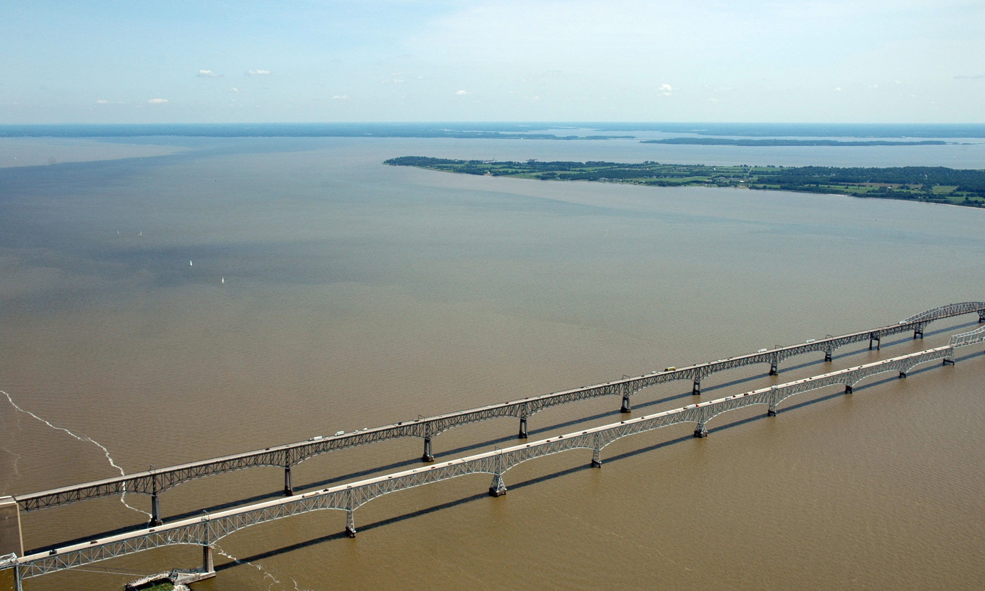
Featured Image: Plumes of muddy, sediment-laden water at the Chesapeake Bay Bridge near Annapolis, MD. Photo courtesy of Jane Thomas/ IAN, UMCES.

Paper: Seabed Resuspension in the Chesapeake Bay: Implications for Biogeochemical Cycling and Hypoxia
Authors: Julia Moriarty, Marjorie Friedrichs, Courtney Harris

A memorable feature of the Chesapeake Bay, the largest estuary in the USA, is that the water is very murky and looks like chocolate milk. Former Senator Bernie Fowler has conducted public “wade-ins” over the past 50 years in one of the Bay’s tributaries, seeing how deep the water is before he can no longer see his white tennis shoes, and let’s just say it is never very deep. This is because of the high concentrations of sediment, or small particles of sand and organic material, in the water. Besides making it harder for seagrasses to grow and serving as food for the economically-important oyster, sediment impacts the biological processes that determine how much oxygen and nutrients are available in the water for algae and fish.

Continue reading “Muddy waters lead to decreased oxygen in Chesapeake Bay”

Iceland’s constantly changing landscape: A Book Review

Featured Image: Lake in a volcano’s crater at Mývatn, Iceland. Photo by Philipp Wüthrich on Unsplash.

Book: Iceland: Tectonics, Volcanics, and Glacial Features, Geophysical Monograph 247 (First Edition, 2020)
Author: Dr. Tamie J. Jovanelly
Figure Illustrations: Nathan Mennen
Additional Text:
Emily Larrimore
Publisher:
American Geophysical Union, John Wiley & Sons, Inc.

I have always wanted to go to Iceland and travel the countryside marveling at the island’s unique geology and icy wonder. Reading through Iceland: Tectonics, Volcanics, and Glacial Features by Dr. Tamie J. Jovanelly, I felt like I got my chance to tour Iceland; this time with a very experienced guide. Dr. Jovanelly has been to Iceland more than ten times since 2006 to explore and study and her familiarity with the place and the people who live there is engrained in this text.

Continue reading “Iceland’s constantly changing landscape: A Book Review”

Isotopes Begin to Unlock the Mystery of Methane Source in the Scheldt Estuary

Scheldt Estuary with tidal flats and water shown

Featured Image: Eastern Scheldt Estuary near Zeeland, Netherlands. Photo courtesy Wikimedia Commons/ Luka Peternel, CC BY-SA 4.0 license.

Paper: Carbon and Hydrogen Isotope Signatures of Dissolved Methane in the Scheldt Estuary

Authors: Caroline Jacques, Thanos Gkritzalis, Jean-Louis Tison, Thomas Hartley, Carina van der Veen, Thomas Röckmann, Jack J. Middelburg, André Cattrijsse, Matthias Egger, Frank Dehairs & Célia J. Sapart

Estuaries are dynamic coastal environments where freshwater and saltwater collide and mix. Across the world, estuaries regularly have higher methane concentrations in the water than would be expected from equilibrium with the atmosphere. If the water was in equilibrium, or at a happy balance, with the atmosphere, then there would be no net transfer of methane to the atmosphere. Because there is more methane than expected in the water, estuaries are a source of this potent greenhouse gas, methane (CH4), to the atmosphere. The problem is that the processes leading to the excess methane in the estuary’s surface water are not well known in many European estuaries.

Continue reading “Isotopes Begin to Unlock the Mystery of Methane Source in the Scheldt Estuary”

What do deep-sea sediment cores tell us about past fish populations?

Black background with fish teeth of different heights and widths

Featured Image: Ichthyoliths (microfossil fish teeth) from deep-sea sediment cores displaying the variety of tooth morphology. Photo courtesy of Elizabeth Sibert, lead author of the paper.

Paper: No state change in pelagic fish production and biodiversity during the Eocene–Oligocene transition

Authors: Elizabeth C. Sibert, Michelle E. Zill, Ella T Frigyik, Richard D. Norris

The seafloor at the bottom of the ocean records what is happening in the water above. Sediments capture silica from diatoms and phytoplankton, carbon from zooplankton poop and detrital marine snow, and teeth after dead fish sink. This last piece of evidence is particularly important: fossilized fish teeth or icthyoliths can help estimate past fish abundance and can show shifts in fish species or biodiversity in the ocean over time.

Continue reading “What do deep-sea sediment cores tell us about past fish populations?”

Hillsides collapsing into Arctic streams can trigger CO2 release to the atmosphere

Permafrost thaw slumps draining into a river on the Peel Plateau in western Canada

Featured Image: Permafrost thaw slumps draining into a river on the Peel Plateau in western Canada. Photo courtesy Scott Zolkos, lead author of the paper.

Paper: Experimental Evidence That Permafrost Thaw History and Mineral Composition Shape Abiotic Carbon Cycling in Thermokarst-Affected Stream Networks

Authors: Zolkos, Scott & Suzanne E. Tank.

The rivers and streams of the Arctic transfer atmospheric heat into the surrounding permafrost (perennially frozen) soil. At the same time, surface soils up to 1 meter deep undergo annual freeze-thaw cycles. When warmer air arrives in the summer months, the combination of warming air and river water can thaw large chunks of ice-rich permafrost soil along the stream’s edge. Thawed permafrost breaks away from the surrounding hillsides and causes catastrophic slope failures, transporting huge amounts of sediment into the nearby waterways. As the stream water becomes murky it takes on the appearance of chocolate milk, and simultaneously, the geochemistry of the water changes.

Continue reading “Hillsides collapsing into Arctic streams can trigger CO2 release to the atmosphere”

Evidence of pollution all the way to the poles

Featured Image: Lake Hazen in front of the Grant Land Mountains – photo courtesy Kyra St. Pierre, a co-author of the Sun et al. paper.

Paper: Glacial melt inputs of organophosphate ester flame retardants to the largest High Arctic lake

Authors: Sun, Yuxin, Amilia O. De Silva, Kyra A. St Pierre, Derek C. G. Muir, Christine Spencer, Igor Lehnherr, John J. MacInnis

Far from human habitation Lake Hazen sits north of the Arctic Circle surrounded by pristine, treeless mountains. But even there, the telltale chemical fingerprints of human pollution can be found.

Spring and summer in the far North are a short three-month period of reawakening, glacial melt, and permafrost thaw. During these months, meltwater transports anything that has collected on top of glaciers, like particles, nutrients, and contaminants deposited from the atmosphere, flowing down rivers and into glacial lakes. 

Continue reading “Evidence of pollution all the way to the poles”

Unexpected consequence of permafrost thaw: potentially less methane released into the atmosphere

Authors: Clarice R. Perryman, Carmody K. McCalley, Avni Malhotra, M. Florencia Fahnestock, Natalie N. Kashi, Julia G. Bryce, Reiner Giesler, Ruth K. Varner

Permafrost is a blanket of soil that is frozen for more than two years and can trap its contents for hundreds to thousands of years. Now that permafrost soil is thawing. This is particularly significant in peatland permafrost because these wetlands sequester high amounts of carbon. As peatland permafrost degrades, methane emissions are expected to increase as the water table rises and provides a suitable environment for methane production by microbes.

Continue reading “Unexpected consequence of permafrost thaw: potentially less methane released into the atmosphere”