One Lake, Two Lake; Green Lake, Blue Lake

A large lake divided by a shallow spit of land, water to the left of the spit appears green and murky, the right side clear and blue.

Paper: Shallow lakes under alternative states differ in the dominant
greenhouse gas emission pathways

Authors: Sofia Baliña, María Laura Sánchez, Irina Izaguirre, Paul A. del Giorgio (2023)

Imagine some of the most dynamic, ecologically important lakes in the world…. you are picturing a deep, wide lake, not something knee deep and murky, or so full of aquatic plants you can’t see the bottom, right? Well, perhaps you should; while they don’t always make the most inviting swimming holes, small, shallow lakes have an outsized importance in the cycling of carbon and other nutrients through the landscape. 

Shallow depths tend to lead to warmer temperatures and more concentrated growth of algae and aquatic plants, not always the most desirable features for recreation.  But what these lakes might lack aesthetically, they make up for with a massive contribution to the global carbon cycle. Combine the abundance of small lakes with a tendency for frequent mixing of the water column, and high rates of organic input from the surrounding watershed and small lakes pack a big punch in terms of cycling nutrients, including carbon, through pathways in both the water and lake bottom sediments. 

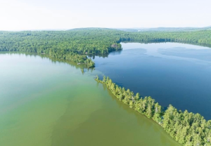
These carbon cycling power houses are tricky to pin down because they can operate in what scientists call two different ‘stable states’: a murky, turbid state, dominated by algal growth that blocks the sunlight from reaching the bottom, and a clearwater state where plants anchored in the lake bottom sediments are dominant. A number of natural events, including floods, droughts, or changes in surrounding vegetation can lead to a ‘flip’ between states. Human activity can lead to a ‘flip’ as well, for example, in the Pampean Plains of Argentina, agricultural practices have added excess nutrients to the system, which tends to push lakes toward the murky, turbid state. The two lake states not only look different from the surface, but also have important differences in rates of photosynthesis, burial of organic material, and circulation in the water.

Knowing the importance of small lakes to global carbon cycling, a team in Argentina did a detailed investigation on how the different states impact carbon cycling and green house gas emissions.  By monitoring sets of turbid and clear shallow lakes in the Pampean Plains over the course of a year, they found important seasonal differences in rates of carbon dioxide (CO2) diffusion into and out of water column, and in the flux of methane (CH4) from lake bottom sediments.

Through monitoring instrumentation suspended in the air above the lakes, as well as measurements taken in the water and sediments, researchers were able to observe weather-driven seasonal changes. The biggest differences were between winter and spring: cold, clear lakes tended to act as CO2 source. When the lakes warmed up, they started to move gas from the water into the atmosphere and became carbon sinks, while turbid lakes did the opposite. 

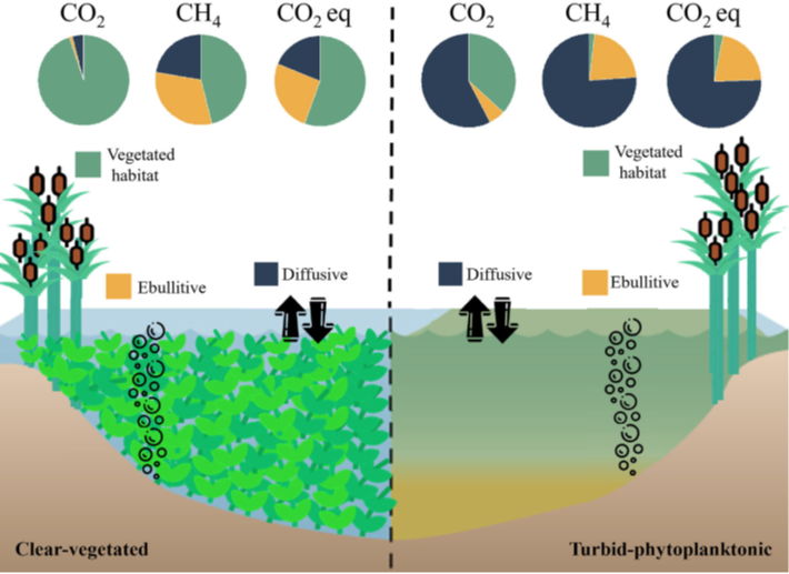
Figure 3 from Baliña et al. (2022) showing the different pathways and relative ratios for carbon flow in clear-water, vegetated lakes (on the left) compared to more green, or turbid, lakes with heavy algal growth on the right. In total, the total greenhouse gas emissions (or CO2 equivalents) for both lake states was similar, but came from different pathways in the lake.

Over an annual cycle, clear lakes had as much as 5 times the CO2 emissions to the atmosphere as compared to turbid lakes, mainly attributed to the vegetation. Turbid lakes, however, had a higher annual emission of CH4. On balance, the two groups of lakes had roughly the same total contribution to green house gas fluxes, but the seasonal variability and differences in carbon pathway are important to understand as we continue to learn more about these dynamic ecosystems and how they change over time.


One Lake, Two Lake; Green Lake, Blue Lake by Avery Shinneman is licensed under a Creative Commons Attribution-ShareAlike 4.0 International License.

Water under Fire

A small, orange-brown lake is set in a deep crater of grey-brown rock

Paper: Modeling Groundwater Inflow to the New Crater Lake at K¯ılauea Volcano, Hawai’i

Authors: SE Ingebritsen, AF Flinders, JP Kauahikaua, and PA Hsieh

Accompaniment to the Third Pod from the Sun episode

When we think of opposing forces in the natural world, fire and water come quickly to mind; elemental powers always at odds, one winning out over the other. There are a few interesting times and places, though, where they can co-exist, occupying some of the same spaces in the landscape.  Perhaps the most visible example of these in the geological world are hydrothermal systems in volcanically active regions, places where earth’s internal heat meets subterranean water with, at times, explosive results.    

For decades the crater at the summit of the Kilauea volcano in Hawai’i, one of the world’s most active volcanoes, was filled with a pool of lava. The constant flow of magma churning up from the volcano’s depths kept this lava lake supplied with fresh molten material.  

That is, until a major eruption in 2018 shifted the volcanic pipelines beneath the lake causing it to empty dramatically at the same time major fissure eruptions were sending waves of lava over residential areas near the eastern flank of the mountain. When a now-empty summit crater began to fill with water, no one was quite sure what to expect.  

Eruptions at Kilauea have been frequent occurrences over the last at least 200 years with varying frequency and intensity. Some of these events have led to what geologists call ‘phreatic eruptions’, highly explosive events that occur when erupting lava comes in contact with cold water causing a high energy eruption of steam, ash, and rock fragments. Often in Hawai’i this occurs when lava flows reach the ocean; however, in the 2018 eruption, groundwater posed a new concern. When the lava lake at the summit began to drop below the water table, both water and lava were essentially trying to fill in the same spaces. At that point there was speculation that some highly explosive events could be imminent as the lava reached the groundwater table and larger volumes of water began to flow into the crater. Relatively little was known about the groundwater table in the area and how long it would take to fill the now empty lakebed emptied of lava. 

Researchers from the U.S. Geological Survey (USGS) hurried to develop new conceptual and numerical computer models to predict how the balance between lava flow and groundwater flow would shift as these internal conduits in the mountain emptied of molten material and began to fill with water. The groundwater flow models were challenged by the temperatures and pressures involved in the Kilauea scenario and initial predictions ranging from 3 to 24 months were narrowed as the lake began to fill in July of 2019, about 14 months after the lava lake collapse. In a paper in the journal Groundwater they explain how water flow was delayed by many months by the inability of groundwater to move through the extremely hot rock. New observations of on the ground conditions, such as inflow, temperature, and evaporation rates helped to refine the existing model to better understand the potential for future interactions in the crater and give volcano observers better tools to predict these potentially hazardous magma-water interactions in future eruptions. 


Water under Fire by Avery Shinneman is licensed under a Creative Commons Attribution-ShareAlike 4.0 International License.

You are what you eat…and also where you fish

Article: Why productive lakes are larger mercury sedimentary sinks than oligotrophic brown water lakes

Authors: Martin Schütze, Philipp Gatz, Benjamin‐Silas Gilfedder, Harald Biester

Advisories and outreach campaigns have worked for years to help us understand how the fish we eat impacts the amount of hazardous mercury we consume. Mercury is present in the environment naturally in several forms, but consumption advisories warn against methyl-mercury. This substance not only moves throughout the aquatic ecosystem, but bio-accumulates, or increases in concentration, as it moves higher in the food chain.  But the size of the fish is not the only influence on its mercury levels – it may also matter where it lives. 

Most mercury in lakes is initially deposited from the atmosphere. These levels vary regionally, influenced by things like weather patterns and local industry. Mercury is also deposited on land, though, and it can eventually leach and erode from soils, moving through surface and groundwater into local lakes. Researchers have known for some time that the vegetation and soil types in the watershed can influence mercury influx to lakes; for example, coniferous trees generally take up more mercury from the atmosphere than deciduous trees, making the forest litter and, eventually, the organic rich layers of forest soils more concentrated in mercury in coniferous forests. 

A recent German study compared mercury levels in two sets of lakes, looking at everything from surrounding vegetation and topography to local weather patterns, and found that previously observed findings held up; mercury levels were higher in leaf litter and organic soils than other surrounding sediments, and higher in areas with more coniferous vegetation. However, when the authors undertook mathematical modelling to balance the input of mercury from atmospheric deposition and local erosion to the outflow, the numbers didn’t add up the same way in all the lakes.

The difference, they documented, was in the productivity of the lakes. Algae scavenge mercury from the water column and, when they die and sink, take the mercury along. This leads to mercury deposition in the lake sediments. By comparing measurements of mercury in the water column, in accumulated sediments on the lake floors, and in sediment ‘traps’ that collect sediment as it is falling through the water column, the researchers showed that large algal blooms significantly increase the transport of mercury from the water column into lake sediments. In a set of forested, alpine lakes that were low in nutrients and had few algal blooms, the monitoring data showed that most of the mercury inputs were eventually lost to a combination of river outflow, re-emission to the atmosphere, and sediment burial. In lakes with higher nutrient loads and more common algal blooms, a similar input of mercury was translated into a much higher flux to the lake sediments, which they traced to the concentration of mercury in the algal organic matter.

The high rate of mercury delivery to lake sediments, especially in very productive lakes, may be bad news for fishing. The high rate of organic matter input to the sediment also leads to a low-oxygen environment which can spur the bacterially-mediated chemical process that turns mercury into the methyl-mercury form. When it is released and recycled from the sediments, it works its way up the food chain. Lakes in many parts of the world are seeing increased algal growth from warmer temperatures and higher nutrient input, and the resultant highly-visible algal blooms may have a significant impact on the invisible movement of hazardous mercury to consumers at the top.


You are what you eat…and also where you fish by Avery Shinneman is licensed under a Creative Commons Attribution-ShareAlike 4.0 International License.

The role of carbon in a changing Arctic

Paper: Freshening of the western Arctic negates anthropogenic carbon uptake potential

Authors: R.J. Woosley and F.J. Millero

Journal: Limnology and Oceanography

As human generated emissions of carbon dioxide continue to increase, scientists seek to understand the potential for ‘sinks’, or places that the excess CO2 can move in the global carbon cycle, to take up and store some of the increased emissions. Understanding how these carbon sinks may react to increasing global emissions helps to better predict both the rate of atmospheric increase in the future and the potential response of global ecosystems, including major sinks in forests and oceans.

Continue reading “The role of carbon in a changing Arctic”

What’s in the Water?

Paper: Contemporary limnology of the rapidly changing glacierized
watershed of the world’s largest
High Arctic lake

Authors: K. A. St. Pierre, V. L. St. Louis, I. Lehnherr, S. L. Schiff, D. C. G. Muir , A. J. Poulain, J. P. Smol, C. Talbot, M. Ma, D. L. Findlay, W. J. Findlay, S. E . Arnott, Alex S . Gardner

As glaciers recede in the arctic, the increase in meltwater may significantly impact downstream ecosystems. Glacial ice can hold thousands of years’ worth of dust, nutrients, and other materials that are released during melting. As the rate of melt increases with a warming climate, the release has the potential to increase nutrient flows and sediment loads, alter pH, and impact other physical, chemical, and biological aspects of downstream watersheds. These changes could negatively impact water clarity and ecosystem function in lakes, rivers, and the ocean.

Continue reading “What’s in the Water?”