Authors: L. Ojha, S. Karunatillake, S. Karimi, and J. Buffo
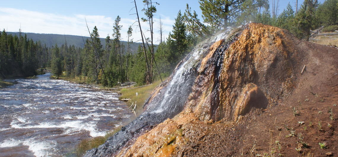
Many people are familiar with Yellowstone National Park’s famous geyser, Old Faithful – but did you know that the heat fueling Old Faithful’s eruptions are from magma chambers that warm up underground fluids until they shoot out of the ground? Hydrothermal systems like this are found in other places, too, and can be fueled by different kinds of heat sources. In fact, scientists at Rutgers University have recently identified one such heat source – the heat generated by radioactive decay from certain chemical elements – that could help answer questions about whether liquid water, a critical component for life as we know it, could exist on Mars.
Drought is often in the news these days, especially in places with arid and semi-arid climates where water is already scarce. While ecosystems have adapted over millennia to cope with dry climates and seasonal droughts, the increasing intensity and frequency of drought due to climate change and human demand for water can pose significant threats to ecosystem health and survival.
Authors: L. Piani, Y. Marrocchi L.G.Vacher H. Yurimoto M. Bizzarro
Vast blue oceans, swirly rain or fluffy white snow – water is ubiquitous on Earth. But where does the water of our solar system come from?
A group of researchers were able to investigate the isotopic composition of water in different components of meteorites. Their findings hint that some of the water on Earth may have originated from a source beyond the solar system.
Authors: Steffen Breinlinger, Tabitha J. Phillips, Brigette N. Haram, Jan Mareš, José A Martínez, Pavel Hrouzek, Roman Sobotka, W. Matthew Henderson, Peter Schmieder, Susan M. Williams, James D. Lauderdale, H. Dayton Wilde, Wesley Gerrin, Andreja Kust, John W. Washington, Christoph Wagner, Benedikt Geier, Manuel Liebeke, Heike Enke, Timo H. J. Niedermeyer, Susan B. Wilde
Over the winter in 1994-1995, the largest undiagnosed mass mortality of bald eagles in the USA occurred at DeGray Lake in Arkansas. In total, 29 eagles were found dead and another 26 were found in the following winter. Other sick individuals were observed overflying perches or colliding with rock walls. Autopsies revealed open spaces called vacuolar lesions in the eagles’ brains and spinal cords. Since this incident, waterbirds with the same neurological disease have been discovered throughout the southeastern USA, which resulted in a severe loss of motor functions and ultimately death in American coots, ducks, geese, and various birds of prey. The new disease was coined Avian Vacuolar Myelinopathy (or AVM).
Since the first outbreaks in 1994-1995, the cause of AVM outbreaks has puzzled scientists. One commonality between all AVM outbreaks was that they were located on or near man-made water bodies; however, the analysis of the lakes and dead birds recovered from outbreak areas did not contain any chemicals or pathogens that were previously known to cause vacuolar lesions in mammals or birds. Moreover, coots and mallards released into AVM outbreak areas developed the disease, but housing healthy and sick birds together outside of AVM outbreak sites did not cause the disease in healthy birds. These results suggested that a novel environmental neurotoxin rather than a pathogen was the cause of the disease. Even then, the identity of the toxin eluded scientists for over 25 years. Now, through a feat of scientific detective work, AVM has been linked to a novel neurotoxin produced by a newly discovered species of cyanobacteria. How did researchers finally solve the mystery?
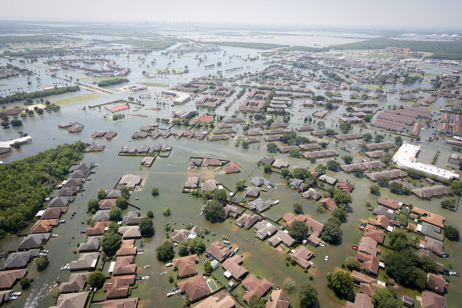
Residents of southeastern Texas are not strangers to hurricane landfalls, including Hurricane Harvey in 2017, which caused 80 fatalities and damaged over 80,000 houses without flood insurance. With the population of coastal areas in the United States expected to continue to grow, understanding how hurricane-associated flooding will change in the future is essential for informing policy decisions and flood resilience strategies. Unfortunately southeastern Texas is facing a triple threat of factors that increase the risk of flooding during hurricane landfalls: land subsidence, sea level rise, and more intense hurricanes.
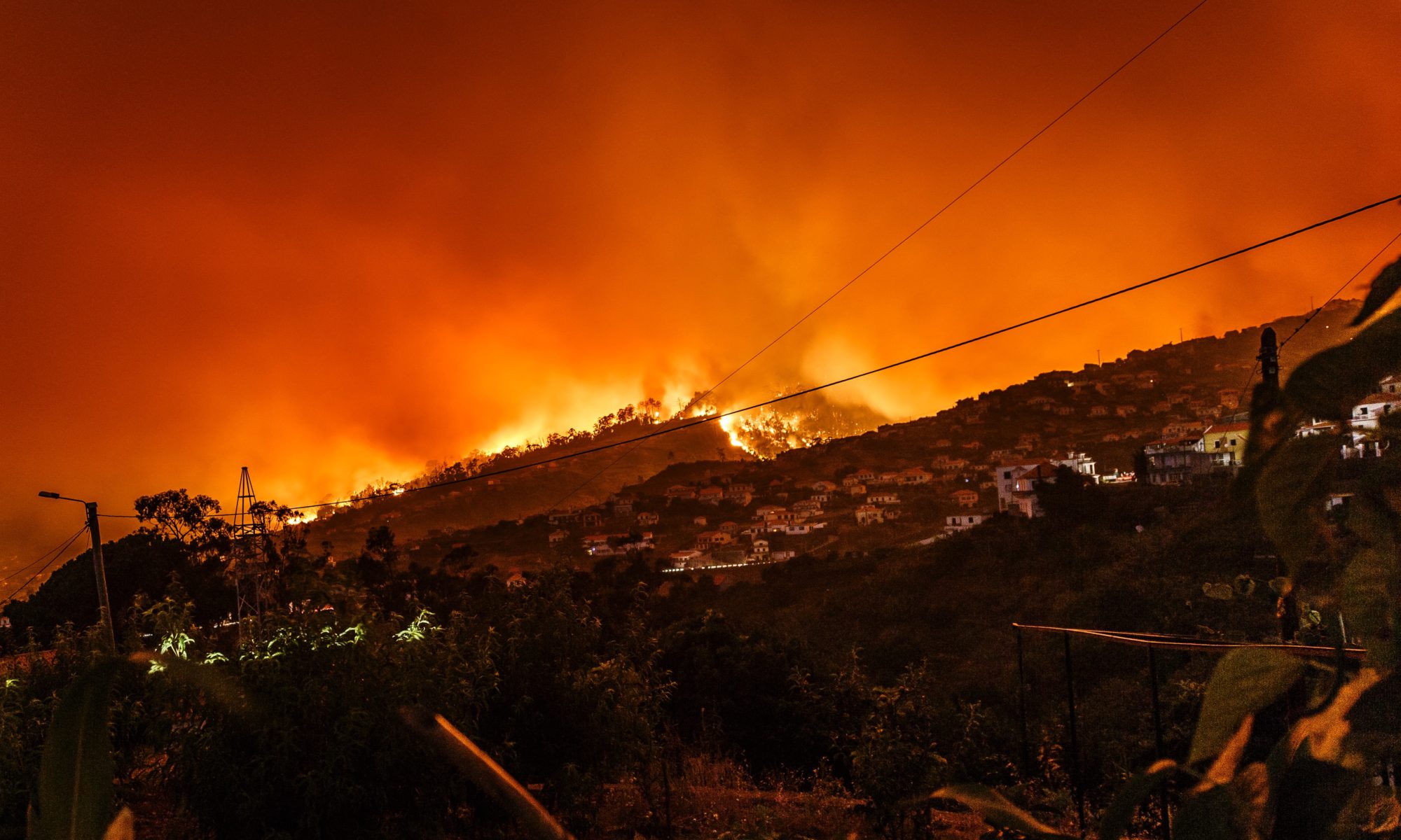
The wildfire season is getting longer and more severe, and current models suggest that this trend will only continue as anthropogenic climate change gets worse. Wildfires dramatically alter the landscape they inundate, leaving vegetation charred and the atmosphere ashy. While jarring, there is one consequence of these natural disasters that isn’t fully understood: their effect on rivers and streams. While it may seem intuitive to think that wildfires disrupt the hydrologic cycle and cause rivers to dry up or shrink, Grady Ball and colleagues found the opposite: wildfires are making our rivers longer.
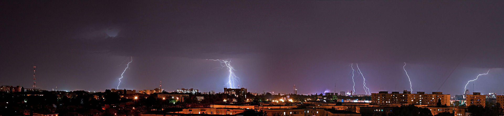
Featured Image: Lightning is a common high energy phenomenon on Earth, like here during a storm over Bucharest, Romania. Image credit: Catalin.Fatu (Wikimedia Commons), CC BY-SA 3.0.
Authors: Benjamin L. Hess, Sandra Piazolo, Jason Harvey
You might think of lightning as a violent and destructive force of nature, but it might have helped to spark life on Earth. The enormous energy released by lightning can weather or even melt rocks. During this short but intense heating phase, the rock’s or soil’s mineralogy changes and a very important element for life becomes available: phosphorus. A group of researches was able to show why the transformation of phosphorus minerals by lightning could have been an important source of this element during Earth’s infancy.
Authors: Dini, B., Bennett, G. L., Franco, A. M. A., Whitworth, M. R. Z., Cook, K. L., Senn, A., and Reynolds, J. M.
Nepal straddles the Himalayan arc – the collision boundary of the Indian and the Eurasian tectonic plates that crumbled to form the highest mountains in the world, the Himalayas. Its precarious location makes it among the most disaster-prone countries in the world. Its landscape has been shaped, and continues to be shaped by seismic activity – from landslides and earthquakes, to glacial lake outburst floods (GLOFs) where the glacier ice or rock debris at the periphery of a glacial lake break off, resulting in severe floods downslope.
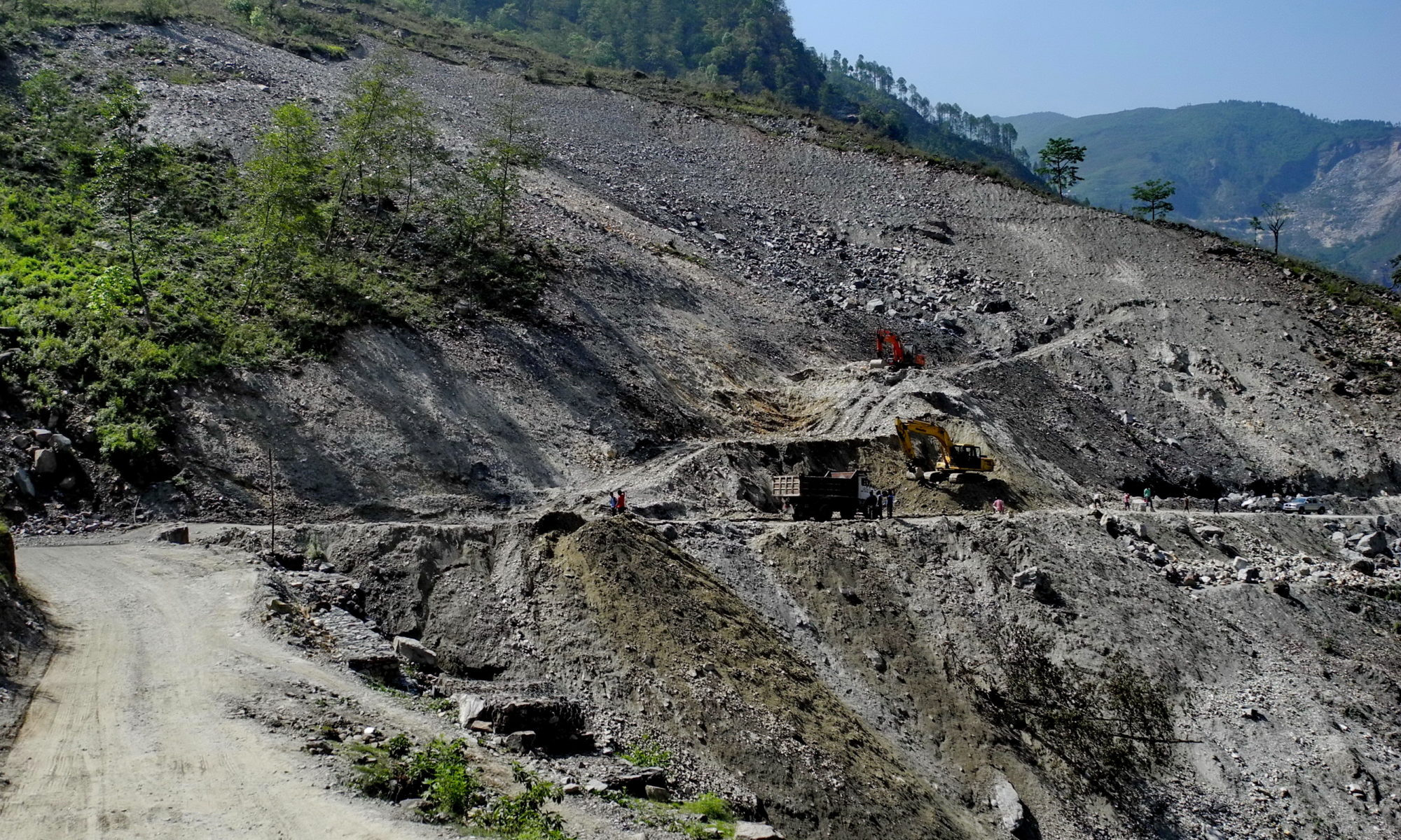
Driving out from Kathmandu city towards Bhaktapur, towards Kodari at the Nepal-China border, the landscape transitions from pagoda-style temples, to settlements, further on to a bleak, boulder-strewn landscape. This is the Araniko highway, built on an old yak track, running alongside the Bhote Koshi river, known to the locals as a difficult, dangerous landscape prone to rockfalls and landslides, especially during the monsoons. Warning signs and steel wire mesh welded to the slopes to mitigate landslides define this stretch, and angular boulders mark where the valleys rise into mountains, and are testimony to the region’s disaster-prone legacy.
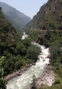
The Bhote Koshi river that flows along the Araniko highway is littered with boulders that have worked loose from the valley slopes. Image credit: Gerd Eichmann (CC BY-SA)
Boulder movement downslope happens due to different kinds of landslides, ranging from abrupt, free-falling rocks to slower flow-like movements. Large boulders are a threat to life and infrastructure, and may amplify landslides when they move downslope or cause floods if they block a river channel.
In fragile landscapes, understanding when and how boulders move downslope and into river networks could be essential to detecting hazards. A rolling stone or a boulder in this case gathers no moss, they say, but can it gather landslide data? A pilot study by Benedetta Dini et al., in the Bhote Koshi catchment, documents how technology can help detect land movement and find use as early warning systems.
Twenty-three long-range, wireless trackers were drilled into boulders along known landslide or debris flow channels. Movement could be triggered by different events including debris flow, large-scale events or collisions. The sensors were programmed to send routine GPS locations every 24 hours, and an accelerometer would report when the boulder moves. A camera was also set up with a field views across the channels to acquire an image every 30 min. Via image sequences, the location of the sensor-embedded boulders are able to compare to prominent trees to identify and validate the movement data. Based on changes in tilt and displacement of boulders, corresponding to movement within a mass of rocks or downslope respectively, the study found that the sensors could successfully detect both slow and rapid movements.
In conclusion, despite technical difficulties which could be a focus for future research, smart boulders have good potential as weather-proof, long-term, real-time, cost-effective monitoring tools, not just in Nepal but in other landslide-prone areas across the world.
Authors: Ulrike Braeckman, Francesca Pasotti, Ralf Hoffmann, Susana Vázquez, Angela Wulff, Irene R. Schloss, Ulrike Falk, Dolores Deregibus, Nene Lefaible, Anders Torstensson, Adil Al-Handal, Frank Wenzhöfer, Ann Vanreusel
Nothing compares to the ethereal beauty of a clear lake. Looking down, you can see a whole world flourishing below: plants, fish, and critters. Compare that to a cloudy, or turbid, lake and suddenly you may feel very small, worried about what’s lurking beneath you. New research shows that the Antarctic ocean is transitioning from clear to turbid water, with big implications for ocean ecosystems.
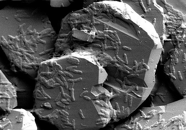
Featured Image: Shewanella putrefaciens CN-32 (a microbe capable of eating iron) on hematite (a rock containing iron). Image courtesy Environmental Molecular Sciences Laboratory (EMSL). Used with permission.
Authors: André Friese, Kohen Bauer, Clemens Glombitza, Luis Ordoñez, Daniel Ariztegui Verena B. Heuer, Aurèle Vuillemin, Cynthia Henny, Sulung Nomosatryo, Rachel Simister Dirk Wagner, Satria Bijaksana, Hendrik Vogel, Martin Melles, James M. Russell, Sean A. Crowe, Jens Kallmeyer
Just as a crow may use a rock to crack a nut, certain microbes can use solid iron to crack open methane. This consumption limits the amount of methane lost from lakes into the atmosphere, making it a crucial process in mitigating production of greenhouse gasses. These microbes are abundant in freshwater sediments, and their specialized mechanism for cracking open methane is most likely one of the oldest metabolisms on Earth, providing a modern-day window into the past.


_(50).jpg)