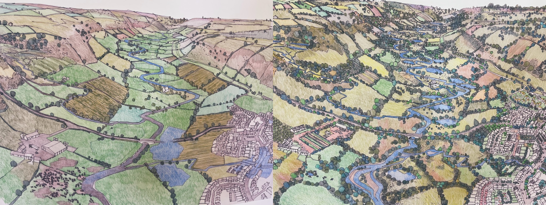
How Elephants Impact the Savannah of South Africa: A Case Study in Rewilding

Featured Image: African Savannah elephants have been long-renowned for their importance in shaping the land they live on. Copyright: CC BY-SA 4.0, via wikimedia commons.

Paper: Elephant rewilding affects landscape openness and fauna habitat across a 92-year period

Authors: Christopher E. Gordon, Michelle Greve, Michelle Henley, Anka Bedetti, Paul Allin & Jens-Christian Svenning

Elephants have an enormous impact on their surrounding environment, particularly through their impact on the openness of the savannah, earning them a reputation as “ecosystem engineers”. Species like elephants, with important influences on the landscape around them, are being studied in efforts to rewild parts of the planet; restoring ecosystems in ways that they can sustain themselves. A recent paper by Gordon et al. explores elephant rewilding across South Africa and assesses its effect on vegetation and animal species across various nature reserves and time spans dating back to 1927. 

Continue readingHow Elephants Impact the Savannah of South Africa: A Case Study in Rewilding

Soot in the water – Understanding oceans’ carbon cycle

Featuring image: soot produced by incomplete burning by fossil fuels. Picture: Pxhere, Public Domain (C0)

Paper: Hydrothermal-derived black carbon as a source of recalcitrant dissolved organic carbon in the ocean

Authors: Y. Yamashita, Y. Mori, H. Ogawa

Earth’s oceans not only harbour a multitude of organisms, they are also a major carbon sink, compensating the increased production of carbon by humans and thus slowing down climate change. But could hydrothermal vents be another source of carbon in the oceans themselves?

A lot of the carbon that is produced on land by organisms and industry is transported into the oceans by rivers and wind. Black carbon (or soot), which is for example produced by incomplete burning of fossil fuels, can be stored in the oceans and remain inaccessible for long periods of time (several thousand years). But is all the stored black carbon coming from land sources? Although scientists already had some hints that not all dissolved black carbon (DBC) in the oceans comes from the land, a reliable evidence for a DBC source within the oceans remained elusive. The research from a group from Japan was able to shine new light on this question by looking at hydrothermal vents in the Pacific Ocean.

Continue reading “Soot in the water – Understanding oceans’ carbon cycle”

One Lake, Two Lake; Green Lake, Blue Lake

A large lake divided by a shallow spit of land, water to the left of the spit appears green and murky, the right side clear and blue.

Paper: Shallow lakes under alternative states differ in the dominant
greenhouse gas emission pathways

Authors: Sofia Baliña, María Laura Sánchez, Irina Izaguirre, Paul A. del Giorgio (2023)

Imagine some of the most dynamic, ecologically important lakes in the world…. you are picturing a deep, wide lake, not something knee deep and murky, or so full of aquatic plants you can’t see the bottom, right? Well, perhaps you should; while they don’t always make the most inviting swimming holes, small, shallow lakes have an outsized importance in the cycling of carbon and other nutrients through the landscape. 

Shallow depths tend to lead to warmer temperatures and more concentrated growth of algae and aquatic plants, not always the most desirable features for recreation.  But what these lakes might lack aesthetically, they make up for with a massive contribution to the global carbon cycle. Combine the abundance of small lakes with a tendency for frequent mixing of the water column, and high rates of organic input from the surrounding watershed and small lakes pack a big punch in terms of cycling nutrients, including carbon, through pathways in both the water and lake bottom sediments. 

These carbon cycling power houses are tricky to pin down because they can operate in what scientists call two different ‘stable states’: a murky, turbid state, dominated by algal growth that blocks the sunlight from reaching the bottom, and a clearwater state where plants anchored in the lake bottom sediments are dominant. A number of natural events, including floods, droughts, or changes in surrounding vegetation can lead to a ‘flip’ between states. Human activity can lead to a ‘flip’ as well, for example, in the Pampean Plains of Argentina, agricultural practices have added excess nutrients to the system, which tends to push lakes toward the murky, turbid state. The two lake states not only look different from the surface, but also have important differences in rates of photosynthesis, burial of organic material, and circulation in the water.

Knowing the importance of small lakes to global carbon cycling, a team in Argentina did a detailed investigation on how the different states impact carbon cycling and green house gas emissions.  By monitoring sets of turbid and clear shallow lakes in the Pampean Plains over the course of a year, they found important seasonal differences in rates of carbon dioxide (CO2) diffusion into and out of water column, and in the flux of methane (CH4) from lake bottom sediments.

Through monitoring instrumentation suspended in the air above the lakes, as well as measurements taken in the water and sediments, researchers were able to observe weather-driven seasonal changes. The biggest differences were between winter and spring: cold, clear lakes tended to act as CO2 source. When the lakes warmed up, they started to move gas from the water into the atmosphere and became carbon sinks, while turbid lakes did the opposite. 

Figure 3 from Baliña et al. (2022) showing the different pathways and relative ratios for carbon flow in clear-water, vegetated lakes (on the left) compared to more green, or turbid, lakes with heavy algal growth on the right. In total, the total greenhouse gas emissions (or CO2 equivalents) for both lake states was similar, but came from different pathways in the lake.

Over an annual cycle, clear lakes had as much as 5 times the CO2 emissions to the atmosphere as compared to turbid lakes, mainly attributed to the vegetation. Turbid lakes, however, had a higher annual emission of CH4. On balance, the two groups of lakes had roughly the same total contribution to green house gas fluxes, but the seasonal variability and differences in carbon pathway are important to understand as we continue to learn more about these dynamic ecosystems and how they change over time.


One Lake, Two Lake; Green Lake, Blue Lake by Avery Shinneman is licensed under a Creative Commons Attribution-ShareAlike 4.0 International License.

‘Cacao’ meteorite and other Fe-Ni meteorites on Mars

Featured image: ‘Cacao’ meteorite in Gale crater, Mars – MastCam mosaic comprised of 19 images. Credit: NASA/JPL-Caltech/MSSS.

Paper: Spectral Diversity of Rocks and Soils in Mastcam Observations Along the Curiosity Rover’s Traverse in Gale Crater, Mars

Author: Rice M S et al., (2022)

On the 28th January 2023 NASA’s MSL Curiosity rover team confirmed the rock ‘Cacao’ as an iron-nickle (Fe-Ni) meteorite on the surface of Mars. Curiosity captured images of a silvery-grey rock, very distinctive among the beige-red sedimentary landscape it is currently exploring. Cacao is a ‘float’ rock, meaning is it not embedded within the bedrock and is not where it formed. Float rocks are common on Mars, but many can be traced back to the upper ledges of slopes they have fallen from, or as ejecta from a nearby impact. Cacao has joined a special group of float rocks that are distinct in appearance, genetic composition, and origin.

Continue reading “‘Cacao’ meteorite and other Fe-Ni meteorites on Mars”

Microscopic Miners: How invisible forces create tropical caves

Featured Image: Scientist Ceth Parker moving through a passageway within an iron formation cave.  Photo courtesy of the University of Akron.

Paper: Enhanced terrestrial Fe(II) mobilization identified through a novel mechanism of microbially driven cave formation in Fe(III)-rich rocks

Authors: Ceth W. Parker, John M. Senko, Augusto S. Auler, Ira D. Sasowsky, Frederik Schulz, Tanja Woyke, Hazel A. Barton

Consider this: microscopic creatures literally moving tons of rock before your very eyes. It seems too fantastical, but maybe not if you’re in the Brazilian tropics. In new work, scientists have detailed these stealthy and microscopic processes, naming a new cave generation pathway called exothenic biospeleogenesis, or “behind-wall life-created” caves.

Continue reading “Microscopic Miners: How invisible forces create tropical caves”

How plants left a mark on history

Featuring image: Plants slowly eroding limestone. Picture from Jon Sullivan, public domain (C0).

Paper: Composition of continental crust altered by the emergence of land plants

Authors: C. J. Spencer, N. S. Davies, T. M. Gernon, X. Wang, W. J. McMahon, T. R. I. Morrell, T. Hincks, P. K. Pufahl, A. Brasier, M. Seraine and G.-M. Lu 

In the winter of 1990, the first Voyager spacecraft looked over its shoulder and snapped an iconic photo of Earth as a ‘pale blue dot’ in the vast cosmos. But when you look at it from Space, there is another very important colour: green. Plants cover a major portion of the landmasses. Besides bringing their bright chlorophyll colour to the continents, new research by Spencer and co-authors finds that plants have also slowly changed the composition of the Earth’s crust over hundreds of millions of years.

In a recent study, Spencer and co-workers were able to connect the development of land plants to changes in the geochemical composition of crustal rocks through the effects that plants had on landscapes, weathering, and sediments. Land plants arose during the early Ordovician period, about 440 million years ago, and today they cover approximately 84% of Earth’s landmasses. After they spread all over the continents, plants started to heavily influence the sedimentary cycles between continents and oceans.

Continue reading “How plants left a mark on history”

From Arizona to Mars: How Impact Craters Have Shaped the Solar System

Featured image: Meteor Crater, located in southwestern United States. Credit: David A. Kring (2017).

Book: Kring, D. (2017) Guidebook to the geology of Barringer Meteorite Crater, Arizona (a.k.a. meteor crater). 2nd edn. LPI Contribution No.2040.

Author: David A. Kring

Impact cratering has been occurring throughout geological time. Earth’s best preserved impact crater lies in Arizona. Barringer Meteorite Crater – or Meteor Crater – formed when an iron meteorite impacted into northern Arizona ~50,000 years ago. Since then, the landscape has seen little erosion, creating a beautifully preserved impact crater. The site can be accessed by tourists only in restricted areas, but the wider crater can be used by select geologists and is used by NASA to train astronauts… and somehow, I found myself there alongside a group of PhD students from across the world.

Continue readingFrom Arizona to Mars: How Impact Craters Have Shaped the Solar System

Water under Fire

A small, orange-brown lake is set in a deep crater of grey-brown rock

Paper: Modeling Groundwater Inflow to the New Crater Lake at K¯ılauea Volcano, Hawai’i

Authors: SE Ingebritsen, AF Flinders, JP Kauahikaua, and PA Hsieh

Accompaniment to the Third Pod from the Sun episode

When we think of opposing forces in the natural world, fire and water come quickly to mind; elemental powers always at odds, one winning out over the other. There are a few interesting times and places, though, where they can co-exist, occupying some of the same spaces in the landscape.  Perhaps the most visible example of these in the geological world are hydrothermal systems in volcanically active regions, places where earth’s internal heat meets subterranean water with, at times, explosive results.    

For decades the crater at the summit of the Kilauea volcano in Hawai’i, one of the world’s most active volcanoes, was filled with a pool of lava. The constant flow of magma churning up from the volcano’s depths kept this lava lake supplied with fresh molten material.  

That is, until a major eruption in 2018 shifted the volcanic pipelines beneath the lake causing it to empty dramatically at the same time major fissure eruptions were sending waves of lava over residential areas near the eastern flank of the mountain. When a now-empty summit crater began to fill with water, no one was quite sure what to expect.  

Eruptions at Kilauea have been frequent occurrences over the last at least 200 years with varying frequency and intensity. Some of these events have led to what geologists call ‘phreatic eruptions’, highly explosive events that occur when erupting lava comes in contact with cold water causing a high energy eruption of steam, ash, and rock fragments. Often in Hawai’i this occurs when lava flows reach the ocean; however, in the 2018 eruption, groundwater posed a new concern. When the lava lake at the summit began to drop below the water table, both water and lava were essentially trying to fill in the same spaces. At that point there was speculation that some highly explosive events could be imminent as the lava reached the groundwater table and larger volumes of water began to flow into the crater. Relatively little was known about the groundwater table in the area and how long it would take to fill the now empty lakebed emptied of lava. 

Researchers from the U.S. Geological Survey (USGS) hurried to develop new conceptual and numerical computer models to predict how the balance between lava flow and groundwater flow would shift as these internal conduits in the mountain emptied of molten material and began to fill with water. The groundwater flow models were challenged by the temperatures and pressures involved in the Kilauea scenario and initial predictions ranging from 3 to 24 months were narrowed as the lake began to fill in July of 2019, about 14 months after the lava lake collapse. In a paper in the journal Groundwater they explain how water flow was delayed by many months by the inability of groundwater to move through the extremely hot rock. New observations of on the ground conditions, such as inflow, temperature, and evaporation rates helped to refine the existing model to better understand the potential for future interactions in the crater and give volcano observers better tools to predict these potentially hazardous magma-water interactions in future eruptions. 


Water under Fire by Avery Shinneman is licensed under a Creative Commons Attribution-ShareAlike 4.0 International License.

Unravelling the secrets of brine pools

Featured image: ROV Deep Discoverer approaching a brine pool in the Gulf of Mexico (2018). NOAA Office of Ocean Exploration and Research (Public domain)

Paper: Discovery of the deep-sea NEOM Brine Pools in the Gulf of Aqaba, Red Sea

Authors: Sam J. Purkis, Hannah Shernisky, Peter K. Swart, Arash Sharifi, Amanda Oehlert, Fabio Marchese, Francesca Benzoni, Giovanni Chimienti, Gaëlle Duchâtellier, James Klaus, Gregor P. Eberli, Larry Peterson, Andrew Craig, Mattie Rodrigue, Jürgen Titschack, Graham Kolodziej, Ameer Abdulla

Today, scientists are turning to extreme ecosystems on Earth to understand how life evolved on Earth and how life might be on other planets. One such alien place exists in the darkness of the ocean. It’s an extreme ecosystem where even fish think twice before entering. Brine pools are well known for being ‘death traps’ – extremely toxic, and any organism (with a few exceptions) that swims into them dies instantly. They are lakes of hypersaline water present on the ocean floor that are so dense that Remotely Operated Submersible Vehicles (ROVs) float on them!

Continue reading “Unravelling the secrets of brine pools”

The Book that Launched the Environmental Movement

Featured Image: Carson’s pioneering work in 1962 made environmental issues a topic that could no longer be ignored. Photo by Frank Hebbert via. Flickr, CC BY 2.0.

Book: Silent Spring (1962)

Author: Rachel Carson

We recently reached a milestone in our history: the amount of land used for farming is now declining, reversing millennia of expansion since early farming gave rise to larger civilizations. This has sparked a debate about how we should use remaining farmland – for example, to restore habitats – and how we can farm more efficiently. As our population continues to grow, and peak at the end of this century, we need to create more food from less land with a reduced environmental impact. 

Continue reading “The Book that Launched the Environmental Movement”