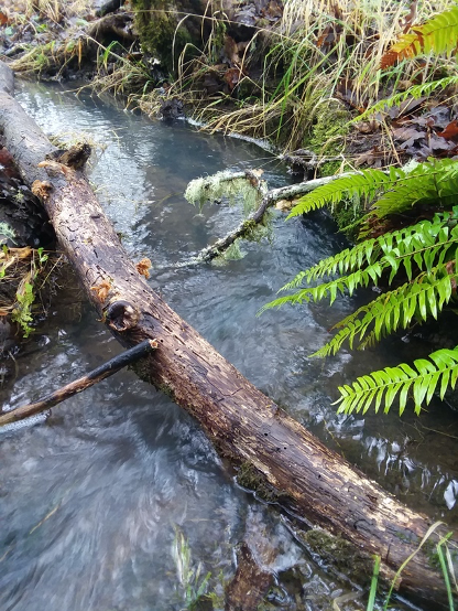
Looking below ground for secrets to drought resilience

Santa Ynez Mountains

Featured image: Oak savanna near the Santa Ynez mountains in California. Clyde Frogg, public domain.

Paper: Low Subsurface Water Storage Capacity Relative to Annual Rainfall Decouples Mediterranean Plant Productivity and Water Use From Rainfall Variability

Authors: Hahm, W. J., Dralle, D. N., Rempe, D. M., Bryk, A. B., Thompson, S. E., Dawson, T. E., & Dietrich, W. E.

Between 2011 and 2016, a severe drought killed over 100 million trees in California. However, not all places responded to this drought in the same way. In some locations, trees and other plants seemed hardly affected, while in other places mortality was widespread. What caused this difference? In a 2019 study, Hahm and colleagues explored the role that water storage in ecosystems has on their resilience to drought. With extreme droughts becoming more common due to climate change, understanding why certain areas are more vulnerable is important for making predictions and improving forest management.

Continue reading “Looking below ground for secrets to drought resilience”

Satellite Technology Helps Discover New Weather Phenomena: Lightning Megaflashes

Featured Image from Bethany Laird on Unsplash

Paper: Where are the Most Extraordinary Lightning Megaflashes in the Americas?

Author: Michael Peterson

Most lightning flashes only last 0.2 seconds, meaning if you blink at the wrong moment, you could miss it. However, scientists have developed new lightning-detection instruments, known as Geostationary Lightning Mappers (GLMs), that never miss a flash. The GLMs are aboard the two Geostationary Operational Environmental Satellites (GOES-West and GOES-East), which are in stationary orbits over the Earth’s western hemisphere. With the data from the GLMs, atmospheric scientists have discovered new lightning phenomena called “megaflashes” which can light up the sky for as long as 16 seconds.

Continue reading “Satellite Technology Helps Discover New Weather Phenomena: Lightning Megaflashes”

Building mountains

Featured image: Yushan (Jade Mountain) in Taiwan. From Wikimedia Commons by Kailing3 under a CC-BY-SA 3.0 license.

Paper: Coseismic Uplift of the 1999 Mw7.6 Chi‐Chi Earthquake and Implication to Topographic Change in Frontal Mountain Belts

Authors: R.Y. Chuang, C.H. Lu, C.J. Yang, Y.S. Lin, and T.Y. Lee

Journal: Geophysical Research Letters

The height of a mountain range results from a hard-fought battle between tectonic plates and the forces of erosion. Earthquakes generated by clashes between plates cause the upward motion of rock even as they shake the landscape, causing large and numerous landslides. When a large earthquake occurs, which process wins? Does more rock go up than come down, leading to a higher mountain range? Or does shaking-induced erosion remove more material than is uplifted by the earthquake? New research suggests that earthquakes might be able to build mountains up faster than landslides can bring them down.

Continue reading “Building mountains”

The role of carbon in a changing Arctic

Paper: Freshening of the western Arctic negates anthropogenic carbon uptake potential

Authors: R.J. Woosley and F.J. Millero

Journal: Limnology and Oceanography

As human generated emissions of carbon dioxide continue to increase, scientists seek to understand the potential for ‘sinks’, or places that the excess CO2 can move in the global carbon cycle, to take up and store some of the increased emissions. Understanding how these carbon sinks may react to increasing global emissions helps to better predict both the rate of atmospheric increase in the future and the potential response of global ecosystems, including major sinks in forests and oceans.

Continue reading “The role of carbon in a changing Arctic”

Deep Sea Bacteria have Thrived for Millions of Years

Image of the ocean floor

Featured Image courtesy Yannis Papanastasopoulos, Unsplash.

Paper: Atribacteria reproducing over millions of years in the Atlantic abyssal subseafloor

Authors: Aurèle Vuillemin, Sergio Vargas, Ömer K. Coskun, Robert Pockalny, Richard W. Murray, David C. Smith, Steven D’Hondt, William D. Orsi

If you, like me, imagine the seafloor to be inhabited by strange, mysterious creatures like vampire squids and goblin sharks, think again: bacteria continue to surprise us with their resilience in the oddest of environments. Scientists have detected microbes living in the mud and rocks on the seafloor, but we don’t know much about them. Are they alive? How do they get energy in such a nutrient-poor environment? Given the inhospitable conditions in the sub-seafloor, scientists have thought that most of these microbes were close to the energy limit for life, which is an estimate of the minimum amount of energy required to sustain life as we know it. For this reason, we’ve assumed that subseafloor microbes die faster than they grow because there simply isn’t enough energy in the deep sea to sustain life long-term. 

Continue reading “Deep Sea Bacteria have Thrived for Millions of Years”

The strange case of the Kansas earthquake

Featured image: Karst rocks in Segovia, Spain. Photo by Luis Fernández García, CC-BY-SA 2.1.

Paper: Injection-induced earthquakes near Milan, Kansas controlled by karstic networks
Authors: Charlène Joubert, Reza Sohrabi, Justin L. Rubinstein, Gunnar Jansen, Stephen A. Miller

On November 12th, 2014, a magnitude 4.9 earthquake rattled the city of Milan, Kansas. This event was the largest earthquake ever recorded in Kansas, adding to a trend of increasing seismic activity in the state since 2012. What could cause this kind of tectonic excitement in the stable central US?

Continue reading “The strange case of the Kansas earthquake”

It’s LeviOsa, Not LevioSA: The Science Of Levitating Mud On Mars

Featured image: A mud volcano and mud flows in Azerbaijan. Credit: CAS/ Petr Brož/ CC BY-SA 4.0.

Paper: Mud flow levitation on Mars: Insights from laboratory simulations

Authors: Petr Brož et al.,

The Mariner spacecraft’s first images of Mars in the 1960s and 70s showed large volcanoes and flow features, most likely lava or mud. These features were largely interpreted to be lava flows because they look similar to those seen on Earth. However, a 2020 study by Brož et al., shows that mud flows may be more prevalent on Mars than first hypothesized. 

Continue reading “It’s LeviOsa, Not LevioSA: The Science Of Levitating Mud On Mars”

Unveiling the Mysterious Patterns of Arctic Cobalt

Featured Image: Fractured sea ice. Image courtesy Pink Floyd 88 a, accessed through Wikimedia Commons GNU Free Documentation License

Paper: Elevated sources of cobalt in the Arctic Ocean

Authors: Randelle Bundy, Alessandro Tagliabue, Nicholas Hawco, Peter Morton, Benjamin Twining, Mariko Hatta, Abigail Noble, Mattia Cape, Seth John, Jay Cullen, Mak Saito

Imagine navigating the Beaufort Sea to the North Pole, crossing icy and treacherous waters through the untamed North, all to chase a metal that is so rare that you have a better chance of finding 5 grains of sand in an Olympic swimming pool*. This is exactly what Bundy et al. accomplished in their work identifying cobalt amounts in the Arctic Ocean and how these amounts vary based on ocean depth, distance from land, and over a time period of 6 years.

Continue reading “Unveiling the Mysterious Patterns of Arctic Cobalt”

New instrument maps and preserves frozen habitats on Earth- and potentially icy worlds

Featured Image: Iceberg in North Star Bay, Greenland by Jeremy Harbeck – NASA, Public Domain

Paper: Subsurface In Situ Detection of Microbes and Diverse
Organic Matter Hotspots in the Greenland Ice Sheet

Authors: Michael J. Malaska, Rohit Bhartia, Kenneth S. Manatt, John C. Priscu, William J. Abbey, Boleslaw Mellerowicz, Joseph Palmowski, Gale L. Paulsen, Kris Zacny, Evan J. Eshelman, and Juliana D’Andrilli

Like the rings of a tree, core samples extracted from glacial ice preserve a unique record of past events. But instead of recording seasonal growth, the ancient ice sheets of Antarctica and Greenland have preserved the conditions of long gone climates and ecosystems. Some sheets have continuously accumulated so much snowfall over the past series of millennia that in some places the ice can reach depths that are miles deep. Analyzing this immense glacial record can inform us about not just the global patterns of climate change, but also the evolution of microbial life on Earth, and maybe even the icy worlds of our Solar System. 

Continue reading “New instrument maps and preserves frozen habitats on Earth- and potentially icy worlds”

Where’s the plastic gone?

Featured image: Plastic pollution in Ghana. Photo courtesy Wikimedia Commons/ Muntaka Chasant, CC BY-SA 4.0 license.

Paper: The global biological microplastic particle sink

Authors: K. Kvale, A. E. F. Prowe, C.-T. Chien, A. Landolvi & A. Oschlies

Scientists estimate that about 4% of the plastic waste generated globally ends up in the ocean, much of it in the form of microplastics. These tiny plastics, smaller than the width of a pencil, are a major pollution problem: because of their small size, they are extremely difficult to remove and can be transferred up the food chain to species that humans eat. Furthermore, harmful chemicals have been shown to adsorb onto microplastics, so consumption of microplastics may have indirect health impacts.  While scientists have put together a “plastic budget” for the ocean by estimating inputs of plastic to the ocean and fragmentation rates of larger plastics into microplastics, models based on observations of the amount of plastic waste in the ocean suggest that there is less plastic in the surface ocean than expected based on these budgets. The authors of this study used a model to test two possible explanations for this ‘missing’ plastic, zooplankton ingestion and sinking to the sea floor with marine particles, and find that these biological pathways can account for 100% of the observed “missing” surface microplastic, even in simulations where these processes are modeled as being inefficient.

Continue reading “Where’s the plastic gone?”