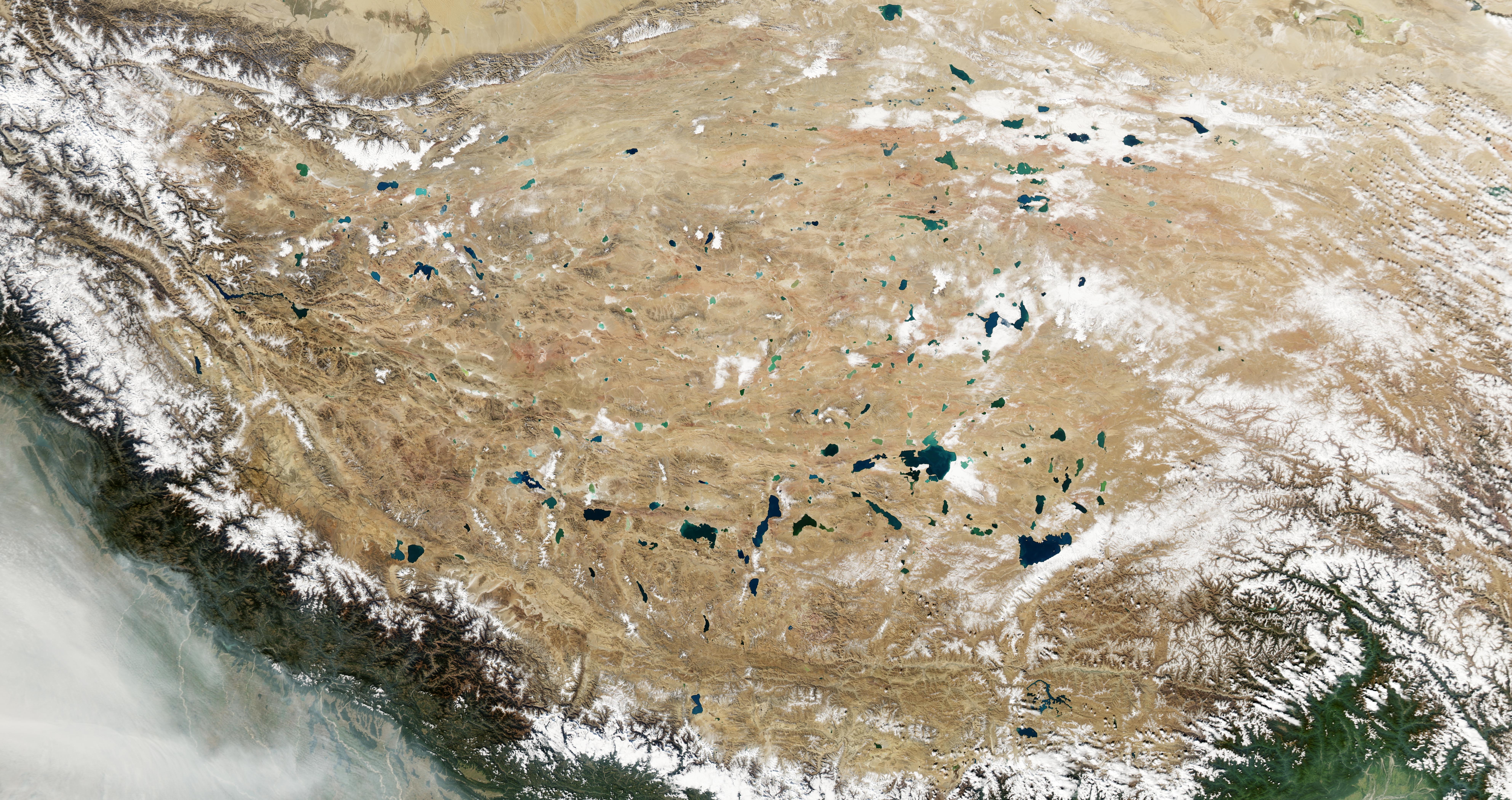
Highway Maintenance “Drives” Carbon Release in Forests

Featured Image: Forest and highway between Trójmiasto and Gdynia, Northern Poland. Image courtesy Robin Hammam.

Paper: The proximity of a highway increases CO2 respiration in forest soil and decreases the stability of soil organic matter

Authors: Dawid Kupka, Mateusz Kania, Piotr Gruba

There has been a lot of talk about transportation as of late with America’s “Build Back Better Act”.  While these political decisions are partially informed by scientific research around climate change, particularly in the United States (where 30% of greenhouse gas emissions result from transportation by road, rail, and air each year), the negative impacts of transportation infrastructure on the climate and local ecosystems are often lost in political discussions.  In a new study in Scientific Reports, Kupka and colleagues discuss the broader impacts of highway maintenance on nearby forest soil ecosystems, finding that roadways themselves can increase carbon dioxide emissions by disrupting local carbon cycles.

Continue reading “Highway Maintenance “Drives” Carbon Release in Forests”

The Charney Report vs IPCC6: What’s changed in climate science in the last 40 years?

NASA satellite image of Earth from space, showing California wildfire smoke visible in the atmosphere.

Papers: Carbon Dioxide and Climate, a Scientific Assessment by Charney et. al (1979);
Climate Change 2021: The Physical Science Basis by the IPCC (2021)

Right now in Glasgow, Scotland, representatives of world governments and other parties are currently gathering yet again to negotiate political solutions to climate change at COP26. This is the 26th semi-annual Conference of the Parties on climate change, but the history of our understanding of the problem — and attempts to deal with it — goes back even further than that. Speaking strictly of the science of global warming and its effects, what do we know now that the participants of the first COP did not?

Continue reading “The Charney Report vs IPCC6: What’s changed in climate science in the last 40 years?”

What can a delta’s history tell us about groundwater’s future?

Feature image: Mosiac of the the Ganges Delta in false color created with imagery from the Sentinal 2 satilite. CC-By Annamaria Luongo, via Wikimedia Commons


Article: Linking the Surface and Subsurface in River Deltas—Part 2: Relating Subsurface Geometry to Groundwater Flow Behavior
Authors: Xu, Z., Hariharan, J., Passalacqua, P., Steel, E., Paola, C., & Michael, H. A.

Deltas are striking features on Earth’s surface, where rivers meet large water bodies. Their flow spreads out into many channels, depositing the sediment they have been carrying, potentially since their headwaters. This sediment creates and sustains the delta, which can be hundreds of miles across. Beyond being mesmerizing, deltas are essential to human civilization, past and present. Nearly half a billion people live on deltas around the world, where the deposited sediment hosts some of the most fertile agricultural land available.

Continue reading “What can a delta’s history tell us about groundwater’s future?”

ExxonMobil and Climate Change Communications: A Case Study in Propaganda

Feature image from Pixabay

Article: Rhetoric and Frame Analysis of ExxonMobil’s Climate Change Communications

Authors: Geoffrey Supran & Naomi Oreskes


It’s no secret that ExxonMobil is a major architect of the climate crisis. The oil giants have allocated incredible amounts of time and resources to undermining climate science while continuing to pollute the planet. Now, a recent One Earth publication by Geoffrey Supran and Naomi Oreskes unpacks the way Exxon has so successfully spread propaganda while borrowing techniques from another destructive industry: that of tobacco. Exxon and other oil companies (often supported by powerful right-wing think tanks) have embarked on a propaganda campaign that has morphed from outright denial into a campaign aimed at distracting us, dividing political opinion, and convincing us that climate action is hopeless. Supran and Oreskes delve into the evolution of Exxon’s harmful contribution to this narrative.

Continue reading “ExxonMobil and Climate Change Communications: A Case Study in Propaganda”

Ancient trees tell the story of modern climate change

Featured Image: Larch trees.  Image courtesy North Cascades National Park, used with permission.

Paper: Spring arctic oscillation as a trigger of summer drought in Siberian subarctic over the past 1494 years

Authors: Olga V. Churakova Sidorova, Rolf T. W. Siegwolf, Marina V. Fonti, Eugene A. Vaganov, Matthias Saurer

Seemingly straight out of a fairytale, ancient trees are able to convey details about Earth’s complex history to the scientists willing and able to listen.  Deep in the Siberian Arctic lie the secrets of past weather events, ocean currents, and droughts that occurred thousands of years ago, locked away in petrified wood and in the oldest living larch trees.  We often hear in the news how the Siberian forest is victim to extreme drought and fire—something that is new as of the recent century.  But how “new” are these events, and what exactly is perpetuating this new cycle? 

Continue reading “Ancient trees tell the story of modern climate change”

How does smoke from wildfires in the western U.S. change the regional climate?

Feature image from Pixabay

Article: Biomass Burning Smoke and Its Influence on Clouds Over the Western U. S.

Authors: C. H. Twohy, D. W. Toohey, E. J. T. Levin, P. J. DeMott, B. Rainwater, … & E. V. Fischer

The area burned by wildfires has been increasing in the western U.S. in recent years and is expected to continue to increase due to climate change. In fact, a large wildfire is currently burning in Sequoia National Park in California, threatening to impact some of the largest and oldest living trees in the world. While wildfires directly impact people, wildlife, and the environment in many ways, a lesser-known impact, involving clouds, can influence the regional weather and climate.

Continue reading “How does smoke from wildfires in the western U.S. change the regional climate?”

Doubling Electricity Production by Storing it!

Pumped Hydro Storage

Paper: The value of CO2-Bulk energy storage with wind in transmission-constrained electric power systems

Authors: Jonathan D. Ogland-Hand, Jeffrey M. Bielicki, Benjamin M. Adams, Ebony S. Nelson, Thomas A. Buscheck, Martin O. Saar, Ramteen Sioshansi

Some storage solutions give back more than we put in

Energy is lost when batteries charge. This is the case for most energy storage solutions – we get out less than we put in. Some storage solutions, however, give back more than we put in, such as hydro-power dams. In these dams, energy is stored as elevated water (potential energy), and rivers add more water (more energy). An international team of researchers recently described an underground storage solution which could more than double the electricity put in and also help reduce CO2 in the atmosphere.

Continue reading “Doubling Electricity Production by Storing it!”

Throwing Earth Off Balance: Evidence Grows that Our Planet is Heating Up Faster than in the Past

Feature image: A satellite looks down at the surface of Earth. Image from Unsplash 

Paper: Satellite and Ocean Data Reveal Marked Increase in Earth’s Heating Rate

Authors: N. G. Loeb, G. C. Johnson, T. J. Thorsen, J. M. Lyman, F. G. Rose, and S. Kato

At the most fundamental level, what causes climate change? Simply put, climate change is a symptom of an energy imbalance with more energy coming into Earth’s atmosphere than is able to go out. This imbalance drives changes in our climate system that scientists around the world study, including warming temperatures, rising sea levels, melting glaciers, and coral reef bleaching. Using two different kinds of observational data, a recent study has found evidence that the energy imbalance is increasing, which suggests climate change will only worsen.

Continue reading “Throwing Earth Off Balance: Evidence Grows that Our Planet is Heating Up Faster than in the Past”

Mercury on the Move

Featured image: Gravel and rocks crushed by the Greenland Ice Sheet.  Image courtesy PennStateNews, used with permission.

Paper: Large subglacial source of mercury from the southwestern margin of the Greenland Ice Sheet

Authors: Jon R. Hawkings, Benjamin S. Linhoff, Jemma L. Wadham, Marek Stibal, Carl H. Lamborg, Gregory T. Carling, Guillaume Lamarche-Gagnon, Tyler J. Kohler, Rachael Ward, Katharine R. Hendry, Lukáš Falteisek, Anne M. Kellerman, Karen A. Cameron, Jade E. Hatton, Sarah Tingey, Amy D. Holt, Petra Vinšová, Stefan Hofer, Marie Bulínová, Tomáš Větrovský, Lorenz Meire, Robert G. M. Spencer

The Greenland Ice Sheet is melting at an astounding rate as our planet continues to warm.  Mercury levels in the glacial meltwater traveling into the ocean are the highest levels ever measured in natural systems and rival heavily polluted rivers in Asia.  By measuring and tracing mercury in the meltwater, Hawkings and coworkers estimated that the Greenland Ice Sheet contributes up to 10% of all mercury found in Earth’s Oceans today.  Where is this mercury coming from within the Greenland Ice Sheet?  It is not actually coming from the ice itself, but rather the rocks that have been crushed under the immense weight of the Ice Sheet over thousands of years.

Continue reading “Mercury on the Move”

The growing threat of hurricane-associated flooding in southeastern Texas

Feature Image: Flooding in Port Arthur, Texas on August 31, 2017 from Hurricane Harvey. Image from Wikimedia.

Article: Assessment of Future Flood Hazards for Southeastern Texas: Synthesizing Subsidence, Sea‐Level Rise, and Storm Surge Scenarios
Authors: M. M. Miller and M. Shirzaei

Residents of southeastern Texas are not strangers to hurricane landfalls, including Hurricane Harvey in 2017, which caused 80 fatalities and damaged over 80,000 houses without flood insurance. With the population of coastal areas in the United States expected to continue to grow, understanding how hurricane-associated flooding will change in the future is essential for informing policy decisions and flood resilience strategies. Unfortunately southeastern Texas is facing a triple threat of factors that increase the risk of flooding during hurricane landfalls: land subsidence, sea level rise, and more intense hurricanes.

Continue reading “The growing threat of hurricane-associated flooding in southeastern Texas”